
Chapter 13 – 1952
February 7-8, 1952 (Kentville and Wolfville)
Thursday and Friday. Went with H.D. Smith on the morning train, and put up at the Cornwallis Inn. There we had lunch with Hockey, Eaton, Kelsall, Creelman, etc. During the afternoon (Thursday) Smith was at Wolfville. I spent the afternoon with Hockey, etc. at the Experimental Farm. Smith and I spent the night at the Cornwallis. 9 a.m. on Friday morning we went over to Acadia. I spent the morning in hiding. We had lunch with a big gang at the Paramount. Returned home by train on Friday afternoon.
April 16, 1952 (Halifax [coordinates 44.632489, -63.592387], MacKeen’s)
Wednesday. Jane Burchill, Martin, MacLeod and I burnt the patches at MacKeen’s. We went down early in the afternoon. The straw was fairly dry, but still damp in spots.
April 19, 1952 (Glen Haven [coordinates 44.641999, -63.91005], C.L. Bennet’s)
Saturday. Jane Burchell, Fred Inglis, Martin, Elizabeth Martin and I went in my car to Bennie’s place at Glen Haven. There Bennie helped us burn the patches. We got water from a pool just across the road from the patches. Bennie’s dog came with us. We had two stirrup pumps, two watering cans and five buckets. We filled them twice. We started burning the patches at Martin’s suggestion from the leeward side which turned out to be the correct method. Martin destroyed one thermometer. He thinks he broke it putting it in the ground, but it may have blown up with the heat. Martin found that the pH was lowered one point by the burn. Mrs. B. gave us tea and buns after burning. I was back home by 6:45 p.m. It was a fine day.
April 30, 1952 (Pleasant Harbour)
Sunday. Borgal and I went down to Pleasant Harbour [coordinates 44.789004, -62.728292] to pick out Blueberry Patches. Wilson, Adshead and Maxwell went with us. We went in my car, and I called for Borgal at 9 a.m. Before dinner, we looked over the patch on Harvey Beaver’s place as well as the large burnt-over area back of Borgal’s and Bill James’ pastures. Borgal went to his own house for dinner and Florence gave the rest of us a magnificent chicken dinner. Then Bill, Borgal and I went over to the Beaver’s house where we arranged for Harvey to clear his patch. Borgal drove home. I arrived home at four minutes to five. The day was showery and while we were at Florence’s there was a very heavy thunder shower.
May 1, 1952 (Lacey River)
Thursday. Jane Bailey, Jane Burchill and I left about 11 a.m. in my car to get sporophytes of the Leafy Liverwort. We located the place where Tony Bidwell took us and left the car on the shoulder of the road. The road in was very muddy for there had apparently been a lot of trucking of lumber over it. There were piles of newly sawn boards all along the road, but at a fork in the road the piles of lumber continued along the left or southern fork. We took the fork to the right. We eventually got to the place where Lacey Mill Lake empties into Lacey River [coordinates 44.844648, -63.814085]. There was a small cabin there, locked, but it had a notice on the door saying that an occupant would be back for the evening. I thought that we had come to the wrong place, for I could not remember the details, but I believe now we were at the right place. We had lunch on a rock near the river. After lunch we went over the little bridge and started on the road leading to Island Lake. We had just gone about one hundred yards and crossed a log bridge when we came to the brook to which Tony had taken us. Going up this brook we found large quantities of sporophytes of Leafy Liverworts. They were the best I have ever seen, and we made a class collection. We started to walk to Island Lake, but it was raining, hailing, etc. and Bailey’s hair was getting in such a bad state, that we went back to the car. We then drove on to Mount Uniacke and had a look at the old foundation of Samuel Bell’s house. This was just to show “Burchie” that my ancestors were just as good and efficient as hers, when it came to running a drinking house and den of iniquity. I bought a pair of garden gloves and some cigarettes at the Mount Uniacke store, then we went on and had a look over the Old Uniacke property. We did not get in the house but saw the modern “fixtures” through the windows. On the way home we tried to locate the Oland property with more or less success, chiefly less. Back in the lab at 4 p.m. and I had coffee with F.R.H.
May 7, 1952 (Truro)
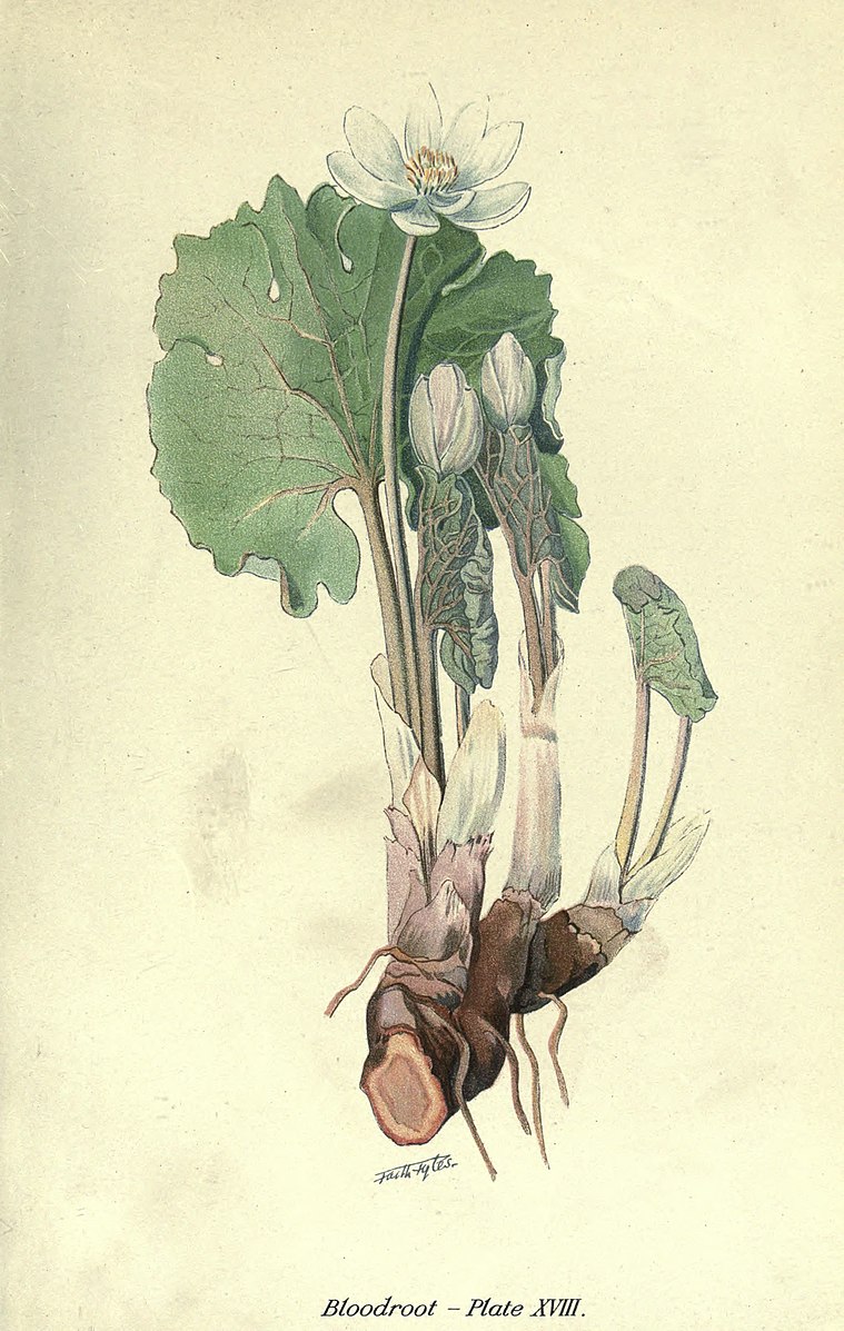
Wednesday. Martin called for me in his car at 8:25 a.m. I was ready and we left at exactly 8:30. We called for Jane Burchill and Jane Bailey and started for Truro. On the way up it started to rain a little. “Burchie” was very sleepy. We first went to Bible Hill and saw Charlie Collins, then to Debert where I saw Roland and Martin saw Hilchie. Roland agreed to take us on a collecting trip on Monday, May 19th. We went back through Truro where Martin bought a lunch including a quart of milk. Lunch was eaten as soon as we got to St. Andrews River [coordinates 45.124284, -63.291499]. It was still misting and cold, but the patch of Hepaticas was located as was an abundance of Bloodroot. Nothing else was out, so far as we could find, so we started off for home and arrived at the Forrest Building at 4:05 p.m. The two girls put the plants in the press. Martin fixed Burchill’s air-bubbling machine. I drank tea. When we “signed-off” Martin had not finished his quart of milk. We got and did all we went for, but it was a cold raw day.
May 14-15, 1952 (Pubnico and Caledonia)
Wednesday and Thursday. On Wednesday morning I left by the 8:40 bus for the Western Shore. H.D. Smith (with Mrs. Smith) picked me up at Mill Village about 12:30. They had spent the night in Lunenburg. We drove on in his car and had lunch at the Ragged Islands Inn. During the afternoon we went down to Pubnico [coordinates 43.702489, -65.784222] and saw the patch which Benoit d’Entremont had burnt. It was coming along but just fairly well. It looked to me as if it were either too dry or had run out. I asked Benoit to look for better and larger areas which could be strawed in the autumn. We left without paying any other visits and spent the night at the Ragged Islands Inn. It was raining intermittently. In the morning we went to Caledonia. From the map which Martin gave us H.D.S. located Telfer Hill and Miss Florence Patterson. I could not have located them without his aid. Telfer Hill is really too unusable to operate with ease and the whole district looked like a lumbering district and not a place suitable for a demonstration blueberry patch. We had a light lunch at the local restaurant. There was a religiously minded boy living with Miss. Florence Patterson. I called up East Chester, got Margorie and invited ourselves for tea. On the way out towards Bridgewater we saw an area which would be good for a blueberry burn. We had tea with Constance at East Chester and were back in Halifax shortly after 6. H.D. drove me to my house.
May 19, 1952 (Truro and vicinity)
Monday. Jane Burchill and Jane Bailey were called for at 8 a.m. Caroline Weld came along too. Caroline drove from Shubenacadie to Truro. We had coffee at the Texaco service station then called for Roland at Bible Hill. He took us along the flats back of the college [coordinates 45.369927, -63.261877]. The early flowers were just out and in perfect condition. We went further up the river to Valley but kept on the north side of the river, then over to Upper Brookside. The Trilliums were not out but we made a number of collections. Many of the flowers were new to me. Back at Roland’s, the girls put flowers in the press and Mrs. Roland gave us lunch. After lunch, Roland took us to the intervale at Kemptown [coordinates 45.469078, -63.073595]. There the Dogtooth Violet, Bloodroot and Spring Beauty were in profusion and formed a carpet of flowers along the river. We then took the road just west of Kemptown and went almost to Earltown. Through the hardwoods we found the same flowers that we saw at Kemptown and one or two more. There was also a very dry blueberry patch which had been poorly burned and in my opinion was no good anyway, too dry. We went back on the MacKenzie Settlement Road and then along the North River Road to Roland’s house. On the way back to Truro along the North River Road, big patches of snow could be seen in many places on the sides of the hills. They were in the open spots and Roland said it was where there had been drifts during the winter. At Roland’s the girls again put the flowers in the press. On the way home we ate the girl’s lunch at the “road-side table”. Caroline drove from Lantz to Halifax. Arrived in Halifax at 6:45. It was fine and warm all day.
May 20, 1952 (Kline Heights)
Tuesday. It being a nice fine afternoon and the scrub women being around our labs, we decided to travel a bit, so Jane Burchill, Jane Bailey and I went over to the Frog Pond to see if we could find a good spot to survey. It looked a bit difficult and perhaps unprofitable due to the great number of bare rocks. We then went past Williams Lake and started to hunt for the path to the top of Kline Heights [coordinates 44.62737, -63.623234]. Shirley Mason had found this path some years ago. We went down Quarry Road, got to the Quarry, reached the top of the hill, admired the view, discussed the history of religion etc. but found no path. On the way out we struck the path. To get to the entrance of the path one must turn right at the last house on the north side and then follow the fence. There, on the top of the hill, we found acres of Hair Cap Moss. It was just at the right stage to collect for class purposes. Back in Halifax at 5 p.m. Bailey went home, Burchie came to the lab.
May 29, 1952 (Chester and Lunenburg)
Thursday. We wished to get Fred Bailey started on making the collections of Lily buds. So, Jane Bailey, Jane Burchill and I started off in my car, having given Mary various warnings by long distance telephone the day before. Marjorie came with us. At Chester we left Marjorie with Constance and Nora. The three of us drove through to Lunenburg getting there before noon. Mary gave us a fine dinner and then Jane instructed Fred in how and when to collect the Lily buds. I had a sleep while the two Janes bought a hat for Burchill. I went up and saw the Hazon Zwickers and also saw the man who makes the metal “Critters.” On the way home we called at Chester where we had tea, picked up Marjorie and Mrs. Knight’s bags. At Hubley on the way home George’s engine started missing badly. By nursing it along we just got to Quinpool Road when the engine passed out. Burchill walked home. Marjorie and Bailey took the trolley. Marjorie had Purdy’s truck come for me. The man fixed the engine.
May 31, 1952 (Bog back of St. John the Baptist)
Saturday. The two Janes and I went out to see if we could spot Gaylussacia dumosa (the Bog Huckleberry), but we could not. The bog [coordinates 44.635918, -63.619743] was full of water but the flies were not bad. The Rhodora and the Pale Laurel (Kalmia polifolia) were in bloom and Bailey collected a bunch. We could not see much of the small cranberry (Vaccinium oxycoccos). There would not be enough there to locate it during the winter. We were back in the lab by 11 a.m.
June 10, 1952 (Silver Lake [coordinates 44.556874, -63.642155])
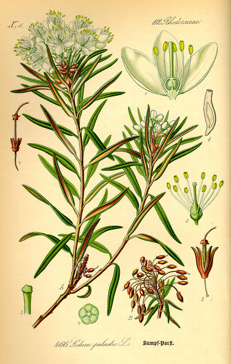
Tuesday. We wished to locate patches of Andromeda and Kalmia polifolia which could be found even in winter when snow covered the ground. The two Janes and I started off at 2:20 in my car. Anne Gorham came with us. There is a big patch of Andromeda at the end of the path just where it hits the lake. This should be reached easily in the winter. The Kalmia is not in big patches but is scattered all through the growth on the water side of the bog. To aid us in locating it, rags were tied around a number of Kalmia plants. Both Andromeda and Kalmia were still in bloom, but the blossoms were almost dropping. The Ledum was just coming out. I was back in the lab by 4:15 p.m. It was a fine hot day.
June 11, 1952 (Kentville and Mill Village)
Wednesday. We wished to see the people in Kentville for advice regarding making the survey of the plot at Pleasant Harbour, so the two Janes and I went up. Janet came with us as far as Wolfville. We started early but were held up by a funeral on the Bedford Road and as a result we did not get to Kentville until 1 p.m. We had lunch on the picnic grounds and then had a long talk with Don Creelman and Fred Hockey. They gave us a lot of help and a number of good suggestions. They also promised to lend us a copy of the report on their own survey (this they brought to my office the next day). Although it was raining, Don Creelman took us out to his plots at Mill Village. The area that he hot burned with a blowtorch the year before had grown up splendidly. It completely fooled me, for I did not think it would work. On the way home we picked up Janet and got to Halifax by 6:10 p.m. It was a dull rainy day.
June 13, 1952 (C.L. Bennet’s, Glen Haven [coordinates 44.641999, -63.91005])
Friday. We wished to see if the rockweed mulch had worked, so the two Janes and I went down in my car during the afternoon. Before going, I was unable to contact Bennie and there was nobody there when we arrived. Both patches were coming along okay but it was still impossible to tell which patch was the better. The rockweed cover was wet and sticky. In places where it was very heavy, there was no sign of blueberry plants. Where it was lighter, the plants were coming through and were at least the same size as they were on the non-mulched plot. There were some showers. We were back in Halifax at 5:15 p.m. I bought some bread. On the way out Quinpool Road “Birchie” took a bucket of young frogs to her aunt.
June 24, 1952 (Mill Cove, Brook from Jack Lake to Paper Mill Lake)
Tuesday. We wished to find a spot where we could get Snowberry plants during the winter, so we went out to the brook where Laura Bisset and I saw them in 1944. The two Janes and I and Marjorie came with us to see the cabinet makers in Bedford. At the brook where we hoped to collect [coordinates 44.720773, -63.686927], the path was practically obliterated as was the woods around the brook. It had been cut over; everything was completely changed. There were no snowberry vines in big clumps. We left early in the afternoon and were back by 4:30 p.m.
June 30, 1952 (Owl’s Nest [coordinates 44.688767, -63.551235])
Monday. The two Janes and I went out to hunt for Mnium for Biology 1. We left at 2 p.m. sharp. We took the correct turns and at the landing place the woman in the hut gave me the oars for Colonel Laurie’s boat. We paddled across to the landing place. There was nobody in the house, so we parked on the verandah. We went to the collecting place for Mnium but there was practically none there and what there was did not look like the right species. On the way back I called in at H.D. Smith’s place and told Mrs. Smith to tell H.D. that the three of us would be going to Cape Breton. The water in Grand Lake was quite high. It was a fine day. We were back in the lab by 5:15 p.m.
July 3, 1952 (Pleasant Harbour)
Thursday. We wished to check on Harvey Beaver’s patch, so the two Janes and I went to Pleasant Harbour [coordinates 44.789004, -62.728292]. Tabby Weld came with us for the trip. We caught the 9 a.m. ferry. Jane Burchill drove from Preston to Musquodoboit Harbour. We ate our lunch on Eric Grant’s wharf and arrived at Harvey Beaver’s while he was having dinner. After he had finished his dinner, we all went over the proposed area. It is even better than I thought and needs very little clearing. We decided to make the patch 170 ft along the road by 255 ft deep. If more convenient for mapping it could be 260 ft deep. After this, Harvey took us over some of the remainder of his available land. He certainly has ample space for a big blueberry development. We then went down and saw Florence. She said that it would be more convenient for her if the two Janes came early in August. We said that would suit us perfectly. Tabby drove the car to Ship Harbour and Jane Burchill drove from Musquodoboit Harbour to outside Dartmouth. We were back in the lab by 4:20 p.m. It was a hot day, but not too hot.
July 7-10, 1952 (Port Hood)
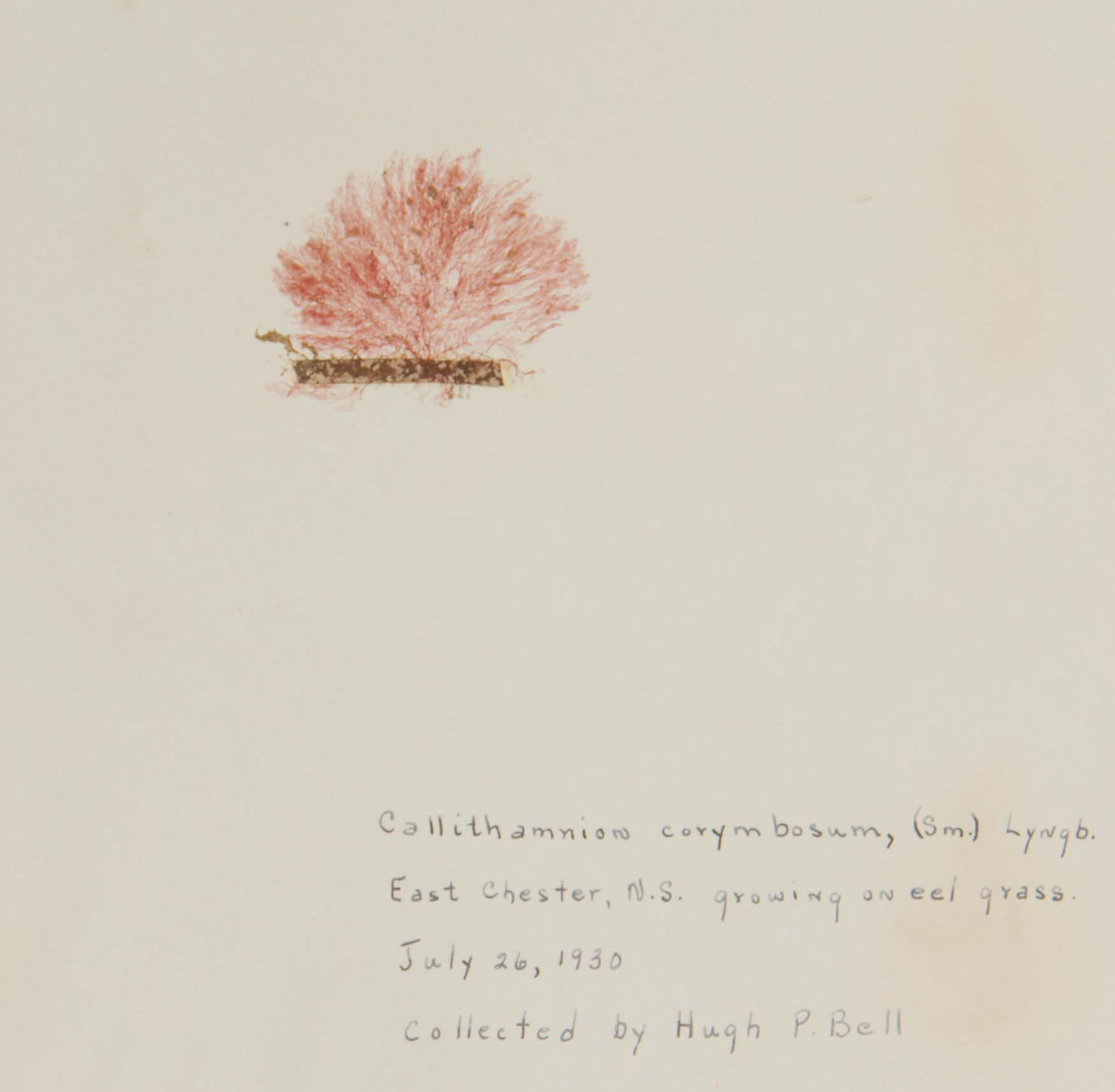
Monday to Thursday. Inspecting Irish Moss situation on the west side of Cape Breton. H.D. Smith and I left in his car about 3:30 p.m. Mr. & Mrs. Gould came with us as super cargo. Supper at lunch counter at New Glasgow and spent the night at Crystal Cliffs. Breakfast with the M.I.T. people, then on to Port Hood [coordinates 46.016177, -61.530911], arriving about 12:15. I put up at the Oceanside Hotel. During the afternoon (Tuesday) Smith and I inspected the shore north past Mabou and almost to Finlay Point [coordinates 46.136441, -61.4645]. There was lots of Irish Moss but it was in deep water only. The intertidal zone and to a depth of two or three feet below low water mark was clear of any growth. H.D. and I had supper at his aunt’s house. He had sort of a conference afterwards. I spent the night at the “Oceanside”. My room was like an oven. Next morning (Wednesday) we all visited the Port Hood Islands. H.D.’s aunt gave us all lunch and after lunch H.D. and I (also Gould) inspected the shore to the south as far as Little Judique Ponds [coordinates 45.950622, -61.527121]. In the bays the Chondrus was infected with Callithamnion but there was lots of clean material on the headlands. Just beyond Little Judique Ponds, but in the same bay, there was a small corner of the shore where the ice in the winter would be stationary. There the intertidal zone was covered with Ascophyllum and the Chondrus was in quantities up to the low water mark. We left Port Hood about 4:00 p.m. (Wednesday) and arrived at Crystal Cliffs at about sundown. We had supper on the beach. Spent the night at Crystal Cliffs. Breakfast (Thursday) with the M.I.T. chaps then started for Halifax. Arriving at 53 Oakland Road about 3 p.m. All three days were fine. Monday, Tuesday & Wednesday very very hot, especially Tuesday. Marjorie was alone in the house all the time I was away.
July 25-27, 1952 (Summerside)
Friday to Sunday. Marjorie and I went over to see Mitchell. Saturday morning I interviewed Mr. Ira W. Ellis regarding the machine for collecting Irish Moss.
July 29-August 1, 1952 (Port Hood)
Tuesday to Friday. Marjorie and I left about 3 p.m. on Tuesday. We had lunch beside the road between New Glasgow and Antigonish. We stayed overnight at Crystal Cliffs, and went on to Port Hood, arriving in time for mid-day meal. We went out in the boat early in the afternoon, but it was too rough to get anything done, so we came ashore and drove to Inverness. We looked at the entrance to Inverness Harbour, which had been filled with silt, then we went to some blueberry barrens, but these were too isolated to be any use. Back in Port Hood we had evening meal and then went to “Aunt Jennie’s” where H.D. was holding a conference with the members of the Inverness Board of Trade. At this conference we arranged to inspect a blueberry patch at 2 p.m. on Thursday. Spent Wednesday night in a cabin at the Oceanview Hotel and during Thursday morning we tried to rake Irish Moss but did not have much success. H.D. had brought with him a Yale chap named Drinker. This chap put on viewing equipment and flippers on his feet, but in general it was all negative. During the early part of the afternoon, we inspected the possible blueberry patches of Malcom MacLeod at Dunvegan [coordinates 46.298244, -61.229432] beyond Inverness. It was an excellent place for demonstration plots. Went back to Port Hood and started for home about 5 p.m. Evening meal at the Goshen where we saw Greenidge and his wife. H.D. went on to Halifax. We took Drinker back to Crystal Cliffs where we spent the night (Thursday). On Friday morning we headed for Halifax, arriving home about 1 p.m.
August 4-5, 1952 (Pubnico)
Monday and Tuesday. Jane Bailey, Jane Burchill and I started in my car at 9:40. We had lunch at Summerville and arrived at Pubnico about 4:30, putting up at Miss Rubens. I immediately saw Bennie d’Entremont and inspected the patches he had picked out. They were perfectly satisfactory and I told him to go ahead. After supper we drove to Bell Neck and saw Lawrence Armstrong and had a very satisfactory talk with him. Apparently, he is the main shipper and buyer for the county. On Tuesday morning at 8:45 we started for Halifax via the valley. En route we went over the fort at Annapolis and the “Habitation”. We had lunch at Granville Ferry. We got back to Halifax at 7 p.m. Going through Berwick we did not see the Camp Meeting. Burchill drove quite a bit, both going and coming. The weather was mighty hot, but we ran into a heavy mist going over Mount Uniacke.
August 15, 1952 (Lake Eagle)
Friday. Jane Burchill and I went to Eagle Lake [coordinates 44.744956, -63.441597] to see the patch that Wallace Findlay and I had mowed. We got there about noon. The plants were growing luxuriantly, and it was difficult to tell whether or not the plants were as dense as an average burnt patch. Like all the bushes in the area they did not have a normal crop of berries, but they had a much greater crop than the adjacent untreated wild bushes. This scarcity of berries may have been due to the long period of dry weather during July. Jane and I had lunch at the usual place beside the lake. We went home via West Chezzetcook and the Lawrencetown beach. Jane drove a fair amount. It was a very hot day.
August 18-19, 1952 (Pleasant Harbour and Necum Teuch)
Monday and Tuesday. Starting about 9 a.m. I took Jane Bailey and Jane Burchill to Pleasant Harbour [coordinates 44.789004, -62.728292] to survey the acre to be burnt. Marjorie came with us. We had lunch at the “Senioretta” at Ship Harbour and saw C.I. MacFarlane. After lunch ($1.50 each) the two Janes were left with Florence and while Marjorie and Florence were talking, I inspected the patch that Bill had burnt. It had grown up very well. Marjorie and I went on to Sheet Harbour where we saw Helen Balcom and Miss Smiley. The latter said the roads were O.K., so I decided to drive on myself. Called at Jack Balcom’s and saw both Jack and Sandy Romkey. Drove on, and Sandy caught up with us just when we reached his house at Necum Teuch. I inspected his plot. It had grown up magnificently. While at Jack Balcom’s, Sandy had engaged a cabin for us with Mrs. Baker at Marie Joseph. So, we continued on and spent the night there in the cabin. Marjorie liked it. On Tuesday morning we called at Romkey’s again, but he was off fishing. We called again at Balcom’s and saw Jack. I wanted Sandy to burn another patch and mulch it with sawdust. Called at Florence’s and saw the two Janes just when they were starting lunch. They had progressed in the survey in a most satisfactory manner. I arranged to come back for them on Saturday. Went over and saw Harvey and arranged for straw, etc. Saw Bill at Lake Charlotte. Home by 4 p.m. Fine weather. Excellent trip.
August 22, 1952 (Sambro)
Friday. During the morning I went with Robertson to inspect his place at Sambro. See letters to both Robertson and H.D. Smith.
August 23, 1952 (Pleasant Harbour)
Saturday. Marjorie and I went down and brought back the two Janes. They had finished the survey. The two Janes went down to Pleasant Harbour on Monday August 18, and came back on Saturday August 23. They completed the job.
August 26, 1952 (C.L. Bennet’s, Glen Haven)
Tuesday. Jane Burchill and I went t Bennie’s place [coordinates 44.641999, -63.91005] during the afternoon to see how the rockweed had worked as a mulch. There was no doubt regarding the evidence. The patch which had been strawed and burned only was covered with a luxuriant growth of blueberries. The patch to which a mulch of rockweed had been applied had a luxuriant growth of garden weeds, such as pigweeds and other plants which had over topped the blueberries. The blueberry growth was rather small and patchy. That is rockweed does not make a good mulch for blueberries. We had better stick to sawdust. It was a fine day. We were back by 6 p.m.
August 28-29, 1952 (Larry’s River and Antigonish)
Thursday and Friday. Martin and I drove in my car to see Father Forrest at Larry’s River. I called for Martin at 8:30 a.m. We had lunch at Antigonish and arrived at Grant’s Hotel Guysborough early in the afternoon. We then drove out to New Harbour and around to Larry’s River. En route we saw some good barrens just on the Larry’s River side of New Harbour [coordinates 45.184017, -61.419891]. Neither Sangster nor Father Forrest were home, but Father Forest was expected back that night. In Guysborough, I bought two pints of stout. During the evening Martin and I looked at maps then walked around the town. On the way down through Antigonish I had called at StFX but did not see anyone except Father Michael MacKinnon’s secretary. On Friday morning we drove out to Larry’s River and saw Father Forrest. He told us about leasing 2000 acres of crown lands. He showed us these. They were excellent for blueberries, but I told him that it would probably be a good idea to mulch part of them with sawdust. Father Forest then went with us and saw the barrens near New Harbour which we had observed the day before. Back in Larry’s River we had a look at the blueberry canning factory in operation. Martin and I drove back to Antigonish via, Isaacs Harbour and Country Harbour. At Antigonish, I called at StFX and left messages for Father MacKinnon. We arrived back in Halifax at 5:25 p.m. Thursday night at Grant’s Hotel was mighty hot. Both days were fine and very hot. Martin drove over half the way.
September 4, 1952 (Sheet Harbour)
Thursday. H.D. Smith called for me in his car at 11:20 a.m. MacGarvey, MacEchran, Miss Tompkins and Miss Campbell went in another car. We had a poor and expensive meal at the Salmon River Lodge then went on to Sheet Harbour, where C.I. MacFarlane had been waiting for us for a long time. We went out in the boat to various islands at the mouth of the harbour [coordinates 44.874333, -62.486153] but did not see any Irish Moss. We had some coffee when we got back to the wharf. H.D. and I started for home, the others waited. H.D. and I attended the opening party of some place in Eastern Passage. Jack MacKeen drove me from the ferry to my house arriving home about 9:00 p.m.
September 8, 1952 (Lacey River and Mount Misery)
Monday. Jane Burchill and I started at 2 p.m. for Lacey River [coordinates 44.829242, -63.810864] to locate buds of Snowberry. We located and marked two patches, we also located and marked some tall blueberry (canadensis). On returning from Lacey River we went to Mount Misery and located some good patches of Huckleberry.
September 9, 1952 (Chebucto Head, Sambro, Silver Lake)
Tuesday. Jane Burchill and I started at 9:20 a.m. First, we called at Halibut Bay [coordinates 44.551116, -63.553767] (Burchie wants to buy the place) and had a look at the rocks there, Chondrus was quite conspicuous. We had a little difficulty in finding the cranberry spot because cottages have been built there and I did not recognize it. But it is just before Camperdown and just at the last “Private Property” sign. There were lots of cranberries there but the box berries would be too hard to find in winter. I re-explored Sandy Cove. It is the same as it always was and hard to turn the car. We had lunch at Robertson’s place at Sambro (Burchie slept and got groggy) then we took the old road to Silver Lake. There we had some difficulty in locating the plants but finally did so. On the way home we went out the Bay Road to look at the fire, but a Mountie told us not to go out the Prospect Road. We obeyed. We were back in the lab about 3 p.m. It was a fine day, and not too hot.
September 10, 1952 (Peggys Cove, etc. Seabright)
Wednesday. Jane Burchill and I started at 9:30 a.m. First, we went to the bog near Seabright [coordinates 44.614547, -63.925612]. I had noticed cranberries there when walking with Wilson, etc. in the spring. We drove the car to the end of the road then walked up and down the hill. There were lots of cranberry vines there, but most of them appeared to be Macrocarpon. As we went down towards Peggys Cove, we had a look at the cottages where Burchie hopes to spend two weeks at Hacketts Cove. It is a mighty nice place, “a good thing.” Just before we got to Peggys Cove we inspected a bog. It used to be on the right had side of the road. It has now moved to the left-hand side. The cranberry vines there were definitely Oxycoccos and just fairly plentiful. We had lunch on the rocks north of the lighthouse at Peggys Cove. Burchie skipped around the rocks like a mountain goat. I thought she would break her neck. After lunch on the way towards West Dover [coordinates 44.495409, -63.876585] we inspected another bog. There was lots of Oxycoccos there, and they had the upright branches in abundance. At Shad Bay we had a look at the picnic grounds and tried to delve into local history. On the way back along the Prospect Road we saw lots of fire engines, but could not see the fire (although Burchie said she felt the heat from it). On reaching the Bay Road, Burchie took a little extra drive just for practice. We were back in the lab about 4 p.m. It was a mighty good day.
September 13, 1952 (Kentville)
Saturday. Jane Burchill and I started at 7 a.m. Jane drove all the way up. It started to rain on the way. We had a long talk with Hockey and Hall. They gave us a lot of good suggestions and criticisms. After that I had quite a talk with Ernest Eaton. Jane and I then went to the Aylesford bog [coordinates 45.029096, -64.819917] [1]. The cranberry plants there are magnificent and are the ones we should use for the winter buds. While there we ate a little lunch which Marjorie had given us. While at the farm, they (Berger) gave us a box of wind-fall Gravensteins. After we left the bog, we went into Berwick to try to get some fruit for Burchie to take home, but could not get any. On the road between Berwick and Kentville we bought a basket of plums and a basket of peaches. At St. Croix we went into Stewarts to get some honey, but Stewart was in a car accident out west and was still in hospital. We got two bottles of honey from a man on the Windsor side of the bridge. Burchie did not like driving the car while it was raining. We arrived home at 3:30 p.m.
September 14-18, 1952 (Chester)
Sunday to Thursday. Marjorie and I went to Chester on the afternoon of Sunday the 14th and returned on Thursday morning the 18th. While there I located a number of good beds of mayflower plants which could be found under the snow.
September 29, 1952 (Sambro)
Monday. H.D. Smith and I went to Sambro [coordinates 44.478563, -63.604887] in his car. We were accompanied by Murphy from Wedgeport in another car. He had three men (one an experienced raker) with him. We went out in the motor-boat and had a look at the beds of Irish Moss. We collected some. Findlay from the store came with us.
December 23, 1952 (Silver Lake [coordinates 44.556874, -63.642155])
Tuesday. Jane Burchill, Norman Becket and I started about 1:30 p.m. It was a rainy day and the roads were muddy and slushy but not really slippery, for the temperature was above freezing, but there was a raw cold wind. Becket got some samples of water, Jane got winter buds of Andromeda, Pole Laurel, Rhodora, Ledum and Leatherleaf. Norman drove home. We were back in the lab by 3:15 p.m.
December 27, 1952 (Bennie’s place, Peggys Cove and West Dover Bog)
Saturday. Jane Burchill and I went to get winter buds. Jane took Johnnie along too. First, we went to Bennie’s place and got those available there. Then we went on to Peggy’s Cove to the small cranberry patch. In the bog on the Halifax side of Peggys Cove I could not find any at first, then I collected what I thought was cranberry, but not satisfied we went on to the bog near West Dover [coordinates 44.495409, -63.876585]. There I again collected the wrong material, but seeing the real low Cranberry plants I realized my mistake, collected the right material and discarded the wrong plants. Johnnie got his feet wet and was acting cold, so we brought him in the front seat, where he said he got warm. With Johnnie in the front seat, we went home.
The way to spot the correct bog near the Dovers [footnone]Dovers refers to West Dover and East Dover.[/footnote] is to go west from Peggys Cove and watch for the Church Steeple of the Dovers. When it appears, one is at the bog.
- Aylesford bog was later developed into a very large commercial cranberry farm. ↵
