
Chapter 5 – 1944
May 18, 1944 (Ship Harbour)
Thursday. Marjorie and I went down to Eric’s at Ship Harbour. We took our car and Mary Bisset drove down with us. We stayed until Sunday afternoon May 21st. Laura drove back with us. On Thursday afternoon Laura and I walked up beside the river nearer Eric’s place. It had been raining during the morning, so the woods were fairly wet but not very. Along the path we found some magnificent fruiting thallose liverwort (Anacrogynae) with long white transparent stalks and nine sporangia. The stalks were at least three inches long. The sporangia were spherical and about 2mm in diameter. We did not go all the way to the lake (1st Lake) but crossed the river. Laura crossed the river first on a thin stick, then she fell in trying to get me across. We returned to the road through the woods and came out quite near the bridge. The dog was with us.
May 19, 1944 (Ship Harbour)
Friday. During the morning Laura and I went to the village. With some difficulty the dog was left at home. Near the first bridge we collected a rock which showed some peculiar white specks and flecks. This was parked beside the bridge. In the village I bought some socks. Laura got eggs etc. and made arrangements about getting electric lights fixed. On the way home we had a look at the Mill and at Dr. Wilson’s house, and finally collected the rock beside the bridge.
In the afternoon, Laura and I took the road that we followed the year before, but this time we kept on going. In places it was fairly damp but passable. We passed one big rocky hill. It lay immediately on our right and Laura wanted to take time off to climb to the top of this rock, but we kept on going. Along the way we collected some likely looking male Haircap moss. We finally reached a fair sized lake. To return we struck roughly south-east, keeping the sun over our right shoulder. At times we kept the lake in sight. Most of the growth was pretty poor stuff consisting of a lot of fir and scrub spruce. Outcrops of bedrock everywhere. The route we followed took us over a number of very steep cliffs. From the last of these, there was an excellent view of the bay. The dog was lost at regular intervals, every fifteen minutes but always turned up. We struck the main road a mile and a half (+/-) northeast of Eric’s house. On the way back we met Bill and Florence James in their car. They told me about young Mason being lost in the Valleyfield. The lake we saw turned out to be Seal Cove Lake and the male Haircap moss provided some excellent living sperms.
May 20, 1944 (Seal Cove)
Saturday. After lunch we went down the road to Seal Cove to see the lake from the other end. On the road I had a talk with Bill James who was operating his road machine. We took the wood road in from Seal Cove and found it pretty wet and fly infested. We came to the lake through low sphagnum swamps. Not being able to see much from this swampy low ground, we circled around the shore, for we could see a cottage well down the western shore of the lake. It was pretty rough going, the “path” being more of a myth than a reality. Finally, we got to the cottage and found that it was situated on a point of land between the two portions of the lake. We went a bit further to make sure there was nothing more to be seen, and also to be sure that there was no more direct path back to Ship Harbour. From the hill back of the cottage we could see the place where we had hit the lake the day before, also some of the steep cliffs. We returned to the road via the way we had come. Laura had a change of shoes.
May 21, 1944 (Ship Harbour)
Sunday. After painting a boat etc. during the morning, we returned to Halifax about 4 p.m. Laura came home with us.
May 23, 1944 (Purcells Cove)
Tuesday. In the middle of the morning L and I went down through the park and crossed by the Purcells Cove ferry to the Quarry Wharf. From there up the Old Quarry Road to the top of the hill. The Jack Pines were just ripe so far as the staminate cones were concerned but dammed if I could locate the pistillate cones, and on that material. I have not located them yet. We made a good collection of staminate cones that were just turning yellow and in a very short time they would have been shedding their pollen. We also made a collection of pistillate cones from the year before. The pistillate cones for 1944 must be somewhere at the tips of those same branches. The sole came off one of Laura’s shoes, we tied it on with a piece of burlap found near one of the batteries. We had lunch on the side of the hill overlooking the lighthouse and walked back along the shore to Williams Lake. On approaching that body of water, we noticed ahead of us a party of troops and females under the command of Dolly McEwen. We circled through the woods and struck the path beyond their encampment. We were hunting for the bog or meadow that I had seen some years before. After climbing several hills, this meadow was located by following down the brook. We came to the main path and were able to locate a very easy way to find and approach the meadow. It is to pass to the SE side (or far side) of the second bog, then follow the brook or bog up. There was not much growth in the meadow, but it gave promise of a heavy growth of that tall grass. We went home by the regular path and passed through and spoke to the McEwen Troops “en route”. Home in time for supper but without any tea.
June 2, 1944 (Newport Corner)
Friday. Mrs. Grant, Margaret (Eric’s Margaret), Mary, Laura and self, left in Mrs. G’s Buick for the Windsor Road. I drove to Newport Corner [coordinates 44.965362, -63.977191] where Laura and I disembarked and started walking down the road to Brooklyn. The growth was luxuriant in marked contrast to, and quite different from, the top of Mount Uniacke. There appeared to be two wild cherries, one out, and one not. Perhaps the wild cherry which was not out, was not a wild cherry or at least a different species. Halfway in to the Meander River there was a larch tree that was very heavily ladened with cones from last year. There were not many cones on it this year (1944), but it should be good next year (1945). It is on the left side of the road when walking from Newport corner to the Meander River and in a wee bit of a bog.
At the Meander River we had lunch beside the river and in a field in front of a big house (Laura provided me with a banana). A lady gave us permission around this house. There were some very large hard maples. Before leaving the Meander we gathered some Chara.
After passing through Brooklyn [coordinates 45.006038, -64.010085] we started along the road to Windsor (pretty thirsty). I located the place where yellow Lady Slippers grow along with the other rare plants that are found at the same place. The yellow Lady Slippers were not quite out (June 2nd). I could find this place without trouble now, but it is hard to describe the exact location. It is not the hill through which the main road has made a cutting, but the similar hill slightly nearer Brooklyn. I should make a map of the place and mark the location. Shortly after we had started again for Windsor, we were picked up by Mr. Campbell the school inspector for Hants and driven to Edgehill School. (Very thirsty) It was a dusty day but slightly warm for a dusty road.
At Edgehill Janet did not appear in spite of the odd whistle from me, so we went over to the college woods and did our collecting (moss for the aquarium in the lab). On returning to Edgehill we located Eve, Patience, Janet and had a drink of water. Saw Miss Rochling and Miss Murray. Talked a lot. Janet came with us when we went for something to eat, which we had at a place that called itself a restaurant. On returning to Bustin’s we were informed that the bus would be two hours late. So, we took Janet back to school, talked some more. Laura helped Janet with her German, then we returned to wait for the bus. After a quarter to ten came and went, Bustin’s admitted they really did not know when the bus would arrive, so I started to look for a free lift. Finally, about 11 p.m. Col. Simmonds came along and drove us home. Some day!
June 6-7, 1944 (Central West River)
Tuesday and Wednesday. Laura and I left by the 8 a.m. bus. On the way to the bus, we heard of the invasion of Europe. Jimmie Fraser met us as scheduled at Central West River [coordinates 45.576883, -62.843801]. He drove us to his house where we had lunch. Then to Charlie Maxwell’s farm. We had quite a job locating the bog. The moss did not appear to be as plentiful as when I was there before but that may have been due to it being much younger and hence perhaps it had not grown or it may have been due to the very dry season. We got lots of females and finally enough males. We sorted them out and put them in killing fluid immediately. Jimmie helped us. On the way back to the main road we saw Charlie Maxwell himself, also his wife. On the way back to Scotsburn, Jimmie took us over Dalhousie Mountain and then to his new church where we saw his new organ and Laura played on it a little. After supper we attended service in Jimmie’s church. The next morning Jimmie drove us to Truro through Earltown and after leaving our stuff at the bus terminals, Jimmie drove us over to the Agricultural College in Truro where we parted company.
Laura and I found that Eric Boulden was away, so we went off on our own and tumbled over the cliff, almost on the top of the Marchantia, then went collecting along the riverbank. The collecting was excellent and there were a lot of things present which I did not remember seeing there (namely a big patch of Yew and fruiting Ostrich Fern. It was raining in fits and starts but not enough to bother us. After climbing up and down the precipice two or three times we were dirty, untidy and hungry so we went to Eric’s house and requested hospitality. This was extended to us in the form of a wash, shelter and a meal. After we got there, it rained pretty hard. We took a taxi from Eric’s house to the bus terminals. Laura thought this was a waste of money. We took the second bus and had a seat all the way home. At the Lord Nelson we took another taxi to the Forrest Building. Laura was sure this was a waste of money. At the Forrest Building we examined the museum material and found it a very early stage but good. Mount Thom trip completed. More than satisfactory in every detail. Taking the second bus home was a good idea.
June 13, 1944 (Hubley)
Tuesday. Laura and I went out to the general region [coordinates 44.578417, -63.770991] of the Big Indian and Little Indian Lakes, Nine Mile River and Big Five Bridge Lake to collect Haircap Moss, Twinflower and to observe what was to be found in that district. It was a dull day with occasional showers, but cool and good for walking. We took my car. Laura drove most of the way out and can drive O.K. She just needs to practice starting on a hill. Parked the car where Josh Umlah used to live. There are two houses there now, each occupied by a son of old Josh. The road to big Indian is OK for a car. Apparently, the road was reconstructed when the dams were built at Big Indian. Nearby Indian we collected quantities of Haircap Moss, both male and female. Then we visited the two dams at Big Indian and crossed over to the other side of the second dam. I forgot my geography and tried to get back to the old road by following the run-out from Big Indian, but when the water of Little Indian was in sight, it was plain that something was wrong. So, we crossed the run-out and circled back to the dam, the diggings for the dam being in full sight through the woods. From there we went back to the old road and walked past Little Indian and had lunch beside the road just beyond the lake.
En route we had collected some very large Haircap Moss, also we had observed that the Twinflower was still in the bud (June 13). Everywhere through the woods there were quantities of Lady Slippers. I never saw so many in one day. If it were desirable to make a collection for Botany 2, this would be a good place to get them.
After lunch we headed for the Nine Mile River. This part of the road does not appear to have changed since we walked it over thirty years ago. At the Nine Mile River, the bridge was down but the water being low we had no difficulty in crossing and so we headed for Big Five Bridges Lake.
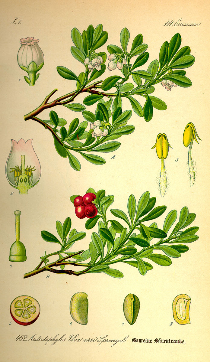
Along the old path, which was still easily followed, we found quite a clump of a yellow flower which turned out to be Hudsonia. We also saw a plant that I had never seen before named Bearberry (Arctostaphylos uva-ursi). The prostrate stem of some of the plants must have been two feet long and in the older parts at least 3/8” in diameter.
The old houses I remembered near this old road were still in existence, but there appeared to be two of them, one completely fallen down and the other in fairly good condition. This latter must have been since my last visit to this place. Also, this old farm clearing was much further from Five Bridges Lake than I had thought.
We finally reached Five Bridges Lake took a bit of a rest and started home. Just when we reached the Nine Mile River it started to rain, and once started, it made a good job of it. We got wet. We reached home about 7:15. I dropped Laura at her house and then took the collections out to the college.
June 20, 1944 (Windsor)
Tuesday. We drove up to the closing at Edgehill. Helen Grant, Marjorie, Laura, Joan Bisset and myself. Joan came home with her mother. Laura sat in the back seat both ways. Rainy day, no botany, nothing to report.
June 28, 1944 (Bedford)
Wednesday. Laura and I went collecting Twinflowers. We took the 10 a.m. Pender’s Bus and got off at Mill Cove near Bedford [coordinates 44.713736, -63.672643]. From there we followed the road into Paper Mill Lake. There were some Twinflowers beside the road that we collected. There is a brook flowing into Paper Mill Lake about half a mile from the Bedford Road. We followed this brook flowing into Paper Mill Lake about half a mile from the Bedford Road. We followed this brook in and found a good woods road running in on the west side of the brook. Along this road we found more Twinflowers and some excellent Snowberry vines. About three quarters of a mile in we had lunch beside the brook. Laura stood in the brook to get her feet cooled off. It was a hot day. After lunch I found an excellent patch of Twinflowers just back of where we had lunch. There we collected, then we started back for the main road and took some Snowberry Vines in with us, as samples, to test for various ways of cutting sections for the Biology 1 set. We waited beside Paper Mill Lake till it was time to start for the 3:18 bus. The bus came a minute sooner than it was expected, with the result that Laura did not finish the orange drink she had bought at the shop. I finished mine. Before we started in the morning Laura bought two grapefruits. I ate one of these. I met Dr. Huntsman while she was buying the grapefruit. He walked down to the bus with us. It was a hot day, but it was cool where we had lunch. Also, there was a little breeze where we waited beside Paper Mill Lake. We were back in the lab by 4 p.m.
July 19, 1944 (Birch Cove)
Wednesday. Laura and I went to the Lakes back of Birch Cove [coordinates 44.682877, -63.656445] to get Snowberry leaves to make sections for the class set in Biology 1. During the first part of the month Laura was occupied helping her family get off to England and I was occupied with Jimmie going to camp Borden, Mitchell going to Big Cove Y.M.C.A. camp, Janet returning form Edgehill etc. During the second week in July, Laura and I made a number of class sets. All these things prevented collecting trips. On Wednesday, 19th we took the 10:10 a.m. Pender’s Bus and got off at Birch Cove, followed the Hammond’s Plains Road a couple of hundred yards, and then struck into the left along the road which had been pointed out to me by Chesley Allen. This road ran along beside a brook bed and is an excellent place for collecting. The brook was almost dry. Along the side of the bank were large quantities of a liverwort, probably an anacrogynous of the Pellia type. The apical flap covering the archegonia could be seen distinctly. There was a lot of hard wood growth; but young trees. We saw a porcupine and a number of young partridges. My hay fever was quite bad. In among the Loosestrife was a St. John’s Wart which had sometimes a single style. We took it home and it turned out to be a Hypericum ellipticum. On the way up to the lakes we spotted some good patches of snowberry leaf. Near the top of the hill, just before reaching the lakes, the flora changed abruptly form the ravine type to the typical barren or heath type. In a little swampy meadow just before reaching the lake we found a flower with a dense large white raceme. I took it home but could make nothing of it. I pressed it for future reference.[1] We had lunch beside the lake, and I ate one of Laura’s plums. The day was fine and cool, just right for walking. We collected the snowberry leaves on the way back and caught a bus at about 3:20 p.m. We took the material to the lab. A good day.
July 24, 1944 (Williams Lake)
Monday. Went on trip to Williams Lake etc. [coordinates 44.620131, -63.595524] to get Loosestrife. Laura called for me at 2:30 p.m. and we went over on Boutilier’s Ferry. A big crowd of Charlie Allen’s summer schoolgirls were waiting on the landing at the foot of Oakland Road. On the way up the hill past Jollimore’s, Laura and I collected some pistillate flowers of Sumach. Laura said she would get the staminate flowers from the bushes at Young Avenue. (This she did) Laura wore the new shoes she had bought downtown during the morning. We picked the Loosestrife beside Williams Lake in the mud flats in front of Serrick’s house. Williams Lake was very low and yellow water lilies completely exposed. We spoke to Mrs. Serrick and she told us how her boy had been killed by our own artillery. Before going into Colpitt, we got permission from a big fat woman to go across her property. On the way into Colpitt Laura took off her new shoes and walked in her bare feet. At Colpitt we turned to the right and passed a boy who was sunning all by himself on the rocks. We went to the place where Laura took her guides. There we rested. Laura tested her penknives and bathed her feet. On the way back, we saw the ashes of a fire that was not completely out, but we had nothing in which to bring up more water. The boy was leaving for home and passed us on the path back. While going along beside Williams lake we met Serrick and had a talk with him. He was returning from work. On our way through the village back of Jollimore’s I found out that Timmie Hunter had moved away, then we bought two tins of grapefruit juice. I drank mine right away. Laura drank hers as we walked along the road and finally disposed of the tin on reaching the arm. We went home and I took the material over to the lab later.
July 25, 1944 (Geizer’s Hill, Fairview)
Tuesday. We went on a trip to find Geizer’s Hill[2] [coordinates 44.649828, -63.662046] from the Chain of Lakes side. We left the lab during the morning, took the tram car to the head of the arm and then up the St. Margaret Bay Road to the Pipe Road. When we got near the dam there was a gate across the road and a sentry behind the gate, so we turned back and crossed the track further down. We started up the hill in the direction of where I thought Geizer’s Hill ought to be. I had not taken this walk for about twenty years. Since then, the growth had become tall and thick and as a result the going was very rough. I kept much too far to the east with the result that we came out at the Ashburn golf links at what used to be the Upper Pasture. Charlie Wright and the Rev. MacKeigan were just coming up to the green. We had a talk to them, and I got out the map to get located and to find my mistake. Charlie Wright advised us to take the road. I wanted to see the country, so we started through the woods. Again, I had a poor idea of direction and kept too far to the left. The going was very rough. I tumbled around at a great rate. Finally, we got to a tall rock, climbed to the top and had our lunch. I had torn my trousers. After lunch we started towards some trees on top of a hill. On the way towards this hill, we spotted the high-tension wires from the north. We made towards these wires and struck them at the point where they make the sharp right turn to the east. We followed this line north, there being a path along the cleared way. Laura collected some Lycopodium plants for mounts. When we reached the road to Geizers’s Hill we followed it to the top of the hill. I missed the lookout tower but Laura spotted it through the woods. We made for it and climbed to the top. From the top there was a magnificent view. We were very thirsty, but Laura produced an orange which we divided and ate. It was a godsend. After resting we descended, went back to the path and followed it to the concrete building. There the path appeared to peter out. So, we started to the lakes through the woods. Laura led the way and kept a good straight course. Again, the going was very rough. The growth was at a very interesting stage. It was very tall and thick compared with the low bushes that covered the slope twenty years ago. The trees consisted of White Birch, Grey Bud Aspen, Red maple, Fir, Spruce etc. The plants were too thickly placed to keep living in their present numbers. They were 15 to 20 ft high and some higher. There were signs that the White Birch was already dying off. My prediction is that without fires or cutting it will (in another twenty years) form a fairly open growth such as we saw on the old Bell property at Mount Uniacke. Laura brought me out about a mile above the dam. The direction she had taken was a little to the left of the sun. Just where we came out there was a nice flat rock beside the lake. We rested there until it was time to start for home. We went along the railway track. There were two men picking berries beside the track. One appeared to know me. We caught the tram car at the head of the Arm and went home. Laura took the Lycopodium to the lab. It was a strenuous but mighty good day. Laura wore her old shoes. Her feet were slightly blistered from the new ones she had worn the day before.
July 26, 1944 (Bedford)
Wednesday. Laura and I took the 10:10 a.m. Pender’s bus to Bedford to visit the Douglas estate. We took the bus to the service station beyond Bedford and walked the rest of the way. Arrived about 12 noon. There was nobody home except John. Prof. and Mrs. Had left for Cape Breton that same morning. Buzzie, Patrick and Helen Creighton [3] were off picking blueberries. John conducted us practically all the way to Black Rock. The whole woods in this region is chiefly a dense spruce second growth. There are some big trees, but most are small (6 inches in diameter) and include a fair amount of Abies [Balsam Fir]. At places the forest floor is completely bare of small herbaceous growth, this is where the overhead cover is very dense. Along the path and under some of the big trees we noticed some twinflowers etc. Along the river there is quite a growth of ferns. At Black Rock I went in for a swim. Laura went further up the river for her bath. We had lunch and then enjoyed the scenery. On the way back we missed the path at the top of the hill, but after considerable wandering around we came out ok. On getting back at the Douglas house we were welcomed by the colored cook. I tried to telephone home but could not get central. The blueberry party arrived back at this point. Buzzie got central and I spoke to Marjorie. We first had tea. Helen Creighton played some of her records, then we immediately had a big supper. Buzzie, Patrick and John conducted us to the bus, which came a little after 7 p.m. We got back to the lab ok. Laura went up to change some bottles. I went up to read an article that had been sent for me to review. About this time, we discovered that we had not eaten Laura’s oranges. Laura went home and I followed a few minutes later, for the smell of turpentine in the lab was too strong for me. On the way home I saw Joan Bisset who asked how Laura had got along.
August 1, 1944 (Preston)
Tuesday. Laura and I drove in my car to Preston [coordinates 44.715695, -63.434226 ], to examine spruces and to have a look at Poison Ivy. Dr. And Mrs. Saunders came with us. We called for the Saunders at 9:30 a.m. We left the car in the usual field and as we walked in, we started to examine trees right away. The Saunders took an interest in the trees too. Laura Located a peculiar bush which turned out to be Corylus Rostrata the Beaked Hazelnut. We took a sample home which we pressed. We took the usual route, observed the Poison Ivy and finally reached the rocks on the main lake. The water in the lake was high, but the paths were dry. We had a bath, then lunch and went back along the south side of the stillwater. There we found a small branch of yew also an excellent beaver dam with a lot of cut trees around it. At the broken-down house, a porcupine was roaming around the foundation. Back at HBB’s place “Richard” started collecting iron for an ice boat. Laura and I started collections and examining spruce. At first Mrs. Saunders came with us. We located a fairly tall tree with a thick base. It did not look like black spruce, but the cones were short and thick with many old cones still attached. Laura went to the top and got samples. We took these samples back to compare with what we had. It looked like black spruce to me, but in that case I had no way of spotting red spruce, so Laura and I went back for more. Laura went to the top of every likely looking tree. We got some excellent material. After resting a short time, we started for home. Beside the main road we bought some raspberries (40 cents a box). Laura got off at the Forrest Building loaded to the scuppers. I took the Saunders home. The day was hot and fine all day.
August 3, 1944 (West Lawrencetown)
Thursday. Helen Grant took us to West Lawrencetown [coordinates 44.668104, -63.378699]. Laura and I collected blueberries early. Laura took these to the lab and then drove her bicycle over to our house. Then Laura, Marjorie and I took my car to Kent St. There, we transferred to Helen’s Mercury. Helen drove with Marjorie in the front seat. Margaret, Laura and myself in the back seat. At West Lawrencetown we had to pay 50 cents to get on the beach. We then drove right along till we were opposite Rainbow Haven. Helen did not like the atmosphere over there. So, she, Marjorie and Margaret drove back. Laura and I walked back. The collecting was magnificent. I did not know any of the plants, so Laura took in all kinds of specimens. The whole Friday and Saturday morning were spent in identifying. Before we were through on Saturday morning Laura had located everything. The first flower was Lechea intermedia or Pinweed. I thought it was a Knotweed and would not have bothered with it. There was a great quantity of a fat succulent plant which turned out to be Salicornia (species undetermined) along with this, was another succulent plant which proved to be Suaeda maritima (Seablite) but at first, I thought it was part of the little blue chickweed Spergularia canadensis (Sandspurrey), but on close examination it was plain they were separate plants (although they grew in the same clump). It was some time before we found Seablite plants with good flowers. There were great quantities of Solidago sempervirens. The flowers were not out. Dixie helped us identify this. There was also lots of Potentilla monspeliensis, Ambrosia artemisiifolia and Limonium carolinianum (Sea lavender). The next day Laura produced a plant of Cakile edentula (Searocket), but I do not remember seeing her collect this plant. Also, the next day she produced a specimen of Impatiens (Jewelweed). Where she got this, I do not know. I do not remember seeing it. For a time, we were completely lost in trying to identify it, for Laura had located the cleistogamous flowers and we were trying to run it through the key with these. Finally, we spotted it. After collecting these flowers Laura and I joined the others under the trees beside the road. We had a swim, then lunch, then everyone disposed themselves according to their respective desires. Laura and I walked back towards the shore opposite Rainbow Haven. It was pretty hot. On the way we collected white spruce. I managed to get up a tree ahead of Laura and got a good specimen of what I took to be typical “Cat spruce.” We continued along the shore right to the place where the bridge had been washed away. The Marine collecting was excellent. In the calm shallow water, there was lots of Ectocarpus, Monostroma, Desmarestia, Dietyosiphon, Chordaria etc. Laura even picked up a specimen of Spongomapha arcta. Also, there was a lot of floating filamentary green which I suppose was Rhizoclonium, Chaetomorpha etc. Laura and I were still in our bathing suits so we waded in for all this. At the actual spot where the bridge used to be, the current was running fast. There the growth included many deep-water forms, such as Chorda, Laminaria, Cystoclonium, Polysiphonia, Ceramium, Halosaccion, Rhodymenia, Rhodomelia, etc. Just around the corner from these rocks there was quite a bed of Scytosiphon. This is certainly a good spot for Marine collecting. It would be worthwhile to examine it on the Rainbow Haven side, for that would be easily reached, being only 10 miles from Dartmouth. Laura and I had another swim, then went back. Laura and Margaret went in for a swim again. We all had tea and started for home catching a ferry at about 6:15. Changed to our car at Kent Street. Laura left on her bicycle for the Forrest Building ladened with spruce trees etc. She looked like one of Macduff’s men about to attack Dunsinane Castle. It was a grand day.
August 10, 1944 (McNabs Island)
Thursday. Went to McNabs Island [coordinates 44.610313, -63.519438] to make observations regarding marine algae growth as it is affected by oil on the beach.
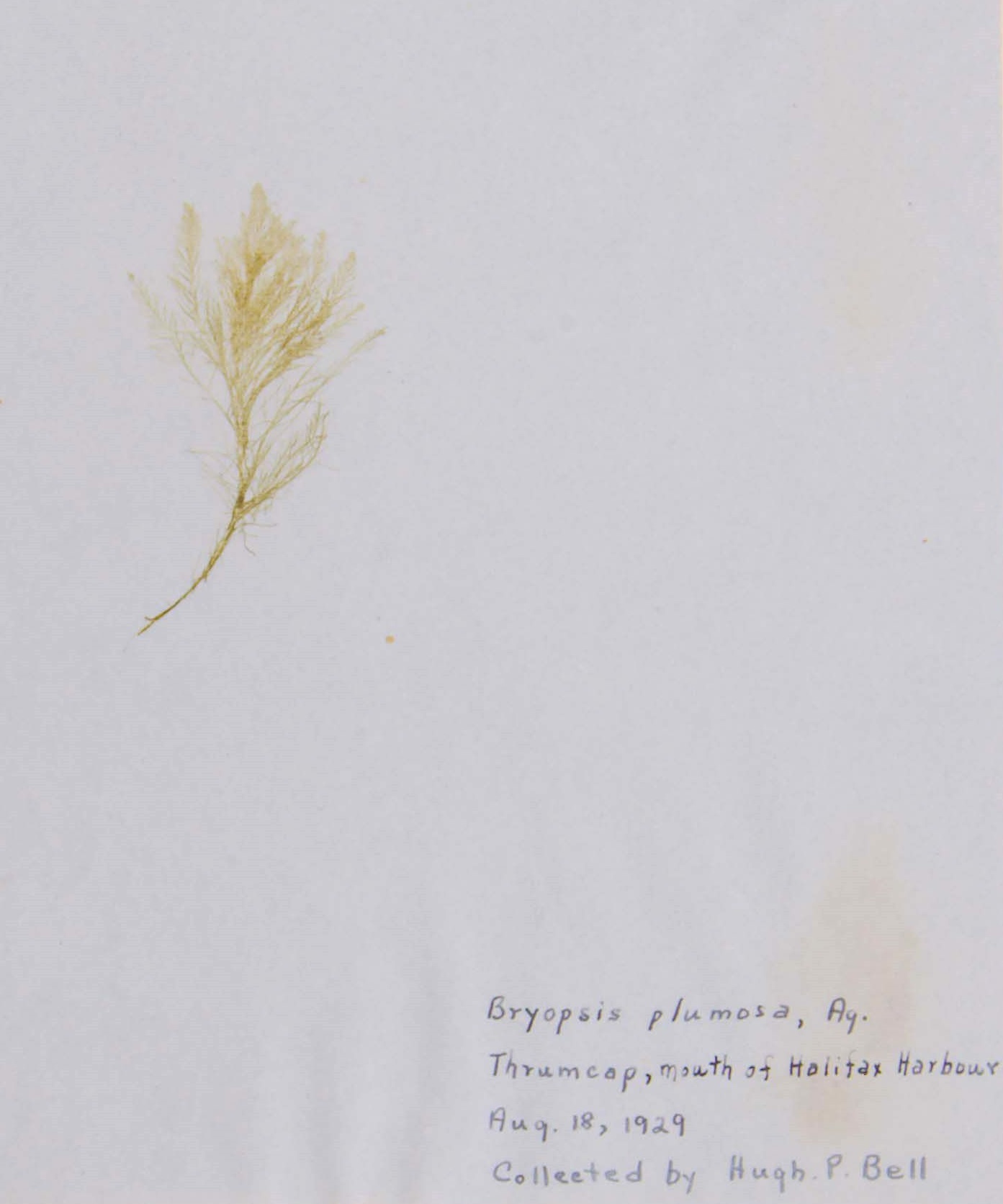
Met Laura at the Forrest Bldg. at 7:30 sharp. Duty boat did not leave till 8:20 and went straight to Ives, then to naval Range Pier. Our passes were checked on the wharf. We then went to the lagoon. The tide pool at the north end of the lagoon was almost completely clear of growth except some small greens. On the Eastern Passage side of the island, the inter-tidal zone was covered with oil, but on the harbour side the oil was not so evident. There was, however, ample evidence of oil at various spots. Whether the bareness of the tide poll was due to the oil or some other factor, is more than I could say. The presence of oil was the most likely explanation, for even though there was not much oil the growth on the rocks in the upper half of the inter-tidal zone did not appear to be as luxuriant as it used to be in 1931. We changed to bathing suits, then the French sentry checked up on our passes. We left our packs etc. in the guard room. Then we proceeded along the barrier reef. The growth in the lagoon included Dictyosiphon, Enteromorpha etc. and appeared to be quite normal. The eel grass formed quite extensive beds. What had changed was the barrier reef. There was no outlet. So, we kept on going past Little Thrumcap to the main outlet which is now on the SE end. It was just about 11 a.m. when we arrived there. The tide had been low at 7:01 a.m. and the water was rushing into the lagoon at a rate that was too fast for comfort. However, I was able to make all the observations that I desired. The growth was exactly the same as the growth in the main outlet in 1930. That is, it included Scytosiphon etc. All the plants were clean, no decay or browning and the Chorda was still covered with the dark brown assimilatory hairs. Just beside the break in the barrier reef there was a large bed of rich dark brown Phylitis; that is everything looked exactly the same as 1930. I did not see the Bryopsis or large attached plants of Desmarestia viridis but I did not hunt very hard. Even in 1930 these were hard to find. We went back via the barrier reef on the SW side, collected our packs (haversacks according to Laura) and proceeded to Maugher Beach, which we reached without being challenged by anyone. The forms washed up on the south side of Maugher beach looked exactly the same as they did in 1930, except I did not notice any Punctaria. From my observations at West Lawrencetown, Point Pleasant and Macnab’s Island, my opinion is that the growth in the inner harbour and Northwest Arm are completely abnormal. In the outer harbour, the forms of the upper half of the tidal zone are stunted and scarce. The deep-water forms of the outer harbour do not appear to be affected. Thus, I would say that Halifax harbour itself would be useless for basic or typical marine biology, but it would not be necessary to go very far away to get perfectly normal conditions. After reaching Maugher Beach, Laura and I picked out a sandy spot on the north side, had lunch, enjoyed the scenery and went for a swim. My knee and hip did not bother me, but I took no chances. We went home via York Redoubt and went back to the lab just to see if it were still there.
August 12, 1944 (Cape Split)
Saturday. I went by the Forrest Building at 7:31 (one minute late). Laura was waiting. We got to the bus just in time to get a seat and then were put in another bus. Arrived at Hantsport about 10 a.m. The day was blazing hot and there was a haze in the air which almost completely obscured the distant view. We walked along the railway track, past a road leading in, till we got to a field. There we struck in towards the shore and found a pond covered with a bright green scum. It was a brighter green than I had ever seen before in Nova Scotia. We actually struck the shore at a little cove, where there were a lot of bricks on the shore. The creek leading into the cove was dry and I could not see any plants of interest. We left our stuff under a tree and started to reconnoitrer for a cool spot. Laura put on her bathing suit and later took to the shore. I went along the top of the cliff. We found a good spot on the cliff beside “Crowell Creek” [coordinates 45.079305, -64.193395] and went back to get our things. Laura along the shore. She went in for a swim before coming in for her things. Then we took everything back to the spot beside Crowell Creek. Laura again going along the shore, she had left her little suitcase at the railway station. Laura was in her bare feet. It turned out later that her shoes (the new ones) had hurt her while she was walking along the railway track. We stayed on the top of the cliff, more or less in the shade and hoped for a cool breeze which did not come. Any breeze which did appear was hot. After lunch, Laura tried to do a chapter of German. We started back for the station a little after 5. Laura walked back along the top of the cliff. At the pond we collected some of the green scum in my mouth wash bottle. The mouth wash contents having leaked out over my pajamas and clean shirt. After collecting the scum, we made for the lower road in Hantsport. Laura got there by crossing an old broken-down aboideau. I followed. In Hantsport it was still blazing hot. At the restaurant I drank many gallons of various types of liquid. Laura drank some too. We returned to the station, ate some oranges, and collected our baggage. Laura was limping. We took the train to Wolfville. Delivered Laura to her Aunt’s and I took a taxi to Kentville and called Laura up on the telephone from Hockey’s. The next morning (Sunday) we picked up Eville about 9 a.m., called for Laura after 9, and arrived at Scott Bay at 10:15. It was another blazing hot day with the same haze obscuring the view. I found the road ok. At the place where I previously found Botrychium etc. we could not find any. After the road ended, I kept to the south side much too far and took the party through fairly difficult and rough softwoods. We landed at Big Cove a half mile from Cape Split. I was completely out in my directions. After a bit of a discussion, they got the correct idea of direction through my head and, after resting a bit, we started off again. This time we made for the north shore. There we found a sort of a path, fairly open hardwoods, and much easier going. We arrived at Cape Split at 12:45 p.m. having tramped for 2 ½ hours. At the Cape it was fairly cool air and the view was magnificent in spite of the haze. The tide rip must have extended out into the bay for nearly ½ a mile and it was roaring like a big river. There were a lot of interesting things. Hockey said the whole top of the Blomidon was, without doubt, too rocky to ever become good farming country. This is of importance when they discuss turning the place into a national park. The bedrock must be close to the surface through the whole area otherwise there would not be so many outcrops, also the soil is full of boulders and small rocks. Both times when I was there before there was no difficulty in finding lots of Botrychium. Why was there none to be seen this time? Eville suggested that perhaps the summer was too dry. Perhaps he is right. Why is there hardwood all along the north side and softwood on the south side? The hardwood trees on the north side looked very old. Why were they so bent? In some of them, the lower part of the thick trunk was parallel with the ground for five or six feet. Many were badly distorted. Probably the wind, but one cannot be sure. We started back about 2 and took the path along the north side. The going was not bad at all. We again hunted for Botrychium but without success. We had been greatly refreshed by Mrs. Hockey’s lunch and tea eaten at Cape Split and made the trip back in about two hours. Laura said her shoes did not hurt her. The car had a flat. We got back to Kentville about 5 p.m. Laura thanked Mrs. Hockey for the lunch. Mrs. Hockey gave us supper. Laura and I got good seats in the bus but were turned out into another bus after passing Mount Uniacke and stood the remainder of the way home. Arrived in Halifax late (about 10:15 p.m.). Laura took the streetcar home. I went to the lab and examined the scum from the pond. It had a strong smell of Thymol. It was a mistake to have put it in my mouthwash bottle, for it was as dead as a doornail, but the material in the pond must have been magnificent. It consisted of what looked like a complete series of the Volvocales. Certainly, Pandorina, Eudorina, Pleodorina and what looked like broken Volvox colonies. There was a great mass of a unicellular form which may have been either a Chlamydomonas or spores from sporulating Volvox colonies. In any case the pond is a possible source of living Volvocales for Botany 2. I must collect there again soon. A plant which Laura and I picked up at Crowell creek was identified by Eville as Actaea rubra (red berries in a raceme). A plant which Hockey spotted at Scott Bay [Footnote]now called Scots Bay[/Footnote] [coordinates 45.302914, -64.39572] is in the press, but it has not been identified up to the present moment.
At Cape Split we observed a bush of Corylus cornuta, the Beaked Hazelnut. The nuts were paired just like the picture in the books.
August 18, 1944
Friday. Laura passed her driving test with Don Logan.
August 22, 1944 (Mount Uniacke)
Tuesday. Laura and I went to Mount Uniacke. I met Laura at the Forrest building at 7:30 and took the 8 a.m. bus. We walked to the Mount Uniacke house along a grass covered road along the side of which were some magnificent big spruce and pine. At the house we were met by Major Uniacke. He took me out to show me the correct direction. When I got back, Laura was talking to three females and a little boy. Before leaving, the oldest of the females took us upstairs and showed us the famous four poster beds, one of which was large enough to hold six people (? God preserve me from such a fate). Then Major Uniacke took us to the end of the path and Laura and I started up-hill in search of Mount Uniacke [coordinates 44.896224, -63.860124] (according to the map it is “Mount Uniacke” but according major Uniacke it is called “Telegraph Hill”). On the way up we passed through an almost pure stand of Abies balsamea. These looked about thirty years old and as Major Uniacke had said that the place had been logged about thirty years ago, I suppose the fir cover had sprung up then. The trees averaged about seven (7) inches in diameter. Laura and I cut open some of the balsam blisters. There was a rich growth of Lycopodium (of about three species), but otherwise the growth was no different from what one would see in any evergreen woods. The trees were tall and numerous hence there was no view. There was some hardwood, and the growth was quite open and the going easy. We passed over a couple of minor hills and finally reached what I took to be the highest point. I shimmied up a spruce tree to make sure. I went up far enough to see that the ground sloped away on all sides and that there was no higher ground anywhere in the vicinity. So, I presumed we were on Mount Uniacke. Leaving there we struck straight downhill to the lake. It was fairly steep; the growth was open with more hardwood. I noted some hard maple and beech. Laura found some Oak fern (on which I spotted rust pustules). We struck the lake too far to the east and walked around the west end till we got to the railway tracks, then east along the railway tracks. Laura spotted some black blueberries. At the first bunch of trees we parked. I went in for a swim and Laura said she went to sleep while I was changing any clothes. We had lunch, argued and started for the railway station. Laura collected more black blueberries and at the shop, we drank orange-ade and waited for the bus (which did not come till nearly 5 p.m.). I did not get a seat with Laura until we were nearly in Halifax. Laura spotted the Douglas house both going and coming. We both went to the lab. Laura did some “cleaning up”. I examined the black blueberries in cross-section. They had ten compartments formed by five compartments being each divided by a false partition. Hence, I suppose they are just black blueberries and not anything else. A good trip. The day was dull, not too warm and no rain. The balsam stand was the best I have seen, and we had some excellent discussions.
September 4, 1944 (Preston)
Monday. Laura and I went to Preston to collect Milkweed for Dave. He wrote from Ottawa asking us to collect and send some up to him. We collected the blueberry first and then started for Dartmouth. We were a bit short of gasoline and it being Labour Day all the stations were shut, but we found Teasdale’s garage open and got some gas there. Laura drove out where we turned in from the main road. Parked the car in the usual place and proceeded as usual. Nothing special observed or collected. We turned in near the north end of the stillwater a bit sooner than usual and found good clear walking close to the water. We had a bit of a discussion as to the interpretation of Dave’s Map, but in any case, we found the milkweed on the rocks just where the run-out from the lake empties into the Stillwater. I found one bunch and Laura found a patch of her own. We each made a collection and at Laura’s suggestion I made a collection of two plants to press. In spite of bare legs and the presence of Poison Ivy, Laura wandered around among the poison plants. We went on to the lake. I had a swim. We ate our lunch. Sat for a while and then went home via our usual route. Laura drove right back to the Ferry. We went to the lab, pressed more plants and looked after some bottles. I got home shortly after six.
September 26, 1944 (Hantsport)
Thursday. We took my car and left 53 Oakland Rd. about 10:30. Heather P. and Janet sat in the front seat with me and Marjorie, Una T and Laura sat in the back seat. We had lunch behind a house on the outskirts of Hansport, right beside the field in which the pond is located. After lunch I took two bottles over to the pond and got them full of water. There was still a scum on the surface, but it was not so extensive nor such a bright green as when Laura and I saw it first. When I went over to get the second two bottles filled Laura went with me. We went on to Avonport via the shore road. Between Avonport and Horton [coordinates 45.10874, -64.29162], we parked beside the field with the Bayberries. Marjorie and Una stayed in the car. The others came in with me to pick Bayberries. Janet and Heather soon got tired, and Laura and I finished the job. There were lots of berries. We drove on to Wolfville by side roads, back to Windsor by the highway and visited at Edgehill. I made a collection of Horse Chestnuts at Edgehill, bought apples along the road, bought honey at St. Croix, and finally got home a little after six.
- A note written in the journal at a later date reads: Filipendula Ulmaria, Queen of the Meadow ↵
- https://web.archive.org/web/20220219122056/https://fairviewhistoricalsociety.ca/geizers-hill-or-geizers-mountain/ ↵
- Helen Creighton was a prominent Canadian folklorist. The Nova Scotia Archives holds a significant collection of archival material related to Dr. Creighton at https://archives.novascotia.ca/creighton/ ↵
