
Chapter 14 – 1953
January 2, 1953 (Lacey River [coordinates 44.829242, -63.810864])
Friday. Jane Burchill could not go out, so I got Anthony to come with me. We left about 1:15 p.m. The ice on the roads had melted. At first, we could not find the marked spot of Snowberry, but we finally located it. We located some Canada blueberry on the way back. In the lab by 4 p.m. I stayed till 7 p.m. locating the snowberry buds. They were damn small. Everything was put in F.A.A. [1] and pumped.
January 5, 1953 (Chester)
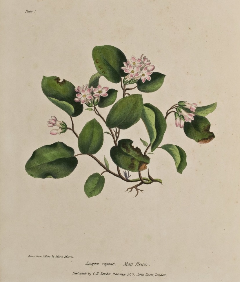
Monday. Mitchell and I took sister Marjorie back to Chester [coordinates 44.537392, -64.223283], starting about 10:45 a.m. Marjorie and I went right into the golf links and collected the mayflowers. I also collected some teaberry. We had lunch then I dissected the mayflower buds and put them in F.A.A. I examined the teaberry but could not see any signs of a terminal bud, or a flower bud, or of any type of bud. I must examine them when growth starts in the spring. We were back at the Forrest Building at 4:10 p.m. It was a gorgeous day.
April 4-5, 1953 (Necum Teuch, etc.)
Saturday and Sunday. I started by myself about 9:15 a.m. in my car. Arrived at Pleasant Harbour [coordinates 44.789004, -62.728292] about noon and had lunch with Florence. After lunch went over to Harvey Beavers and saw him burn a small patch in the middle of his acre. He got a good burn. He had only enough straw to cover a small patch in the middle of his acre. I went on to Sheet Harbour, picked up Helen Balcom and then headed to Port Dufferin where I left my satchel. We then went on to Necum Teuch [coordinates 44.960862, -62.224272] where Sandy Romkey showed me his patch. It was coming along splendidly and if it bears good berries, he will burn a large area this autumn. Sandy’s father had burnt a patch across the road, but he had done it without straw and it was patchy. Went back to Port Dufferin and spent the night at the Balcom’s. Next morning, I went to the 8 a.m. service with Helen and after service we visited with sister Nichols (Mrs. Bishop) at the Rectory. After mid-day meal we started for Halifax, arriving back about 4:30 p.m. Helen Balcom drove back with me. I called in at Eric Grant’s place at Ship Harbour both going and coming, there was nobody home.
April 22-23, 1953 (Shelburne, Pubnico, etc.)
Wednesday and Thursday. Marjorie and I started a little after 9 a.m. in my car. I was going fairly fast after we left Liverpool and the car overheated. We arrived at the Ragged Islands Inn about 12:30 and after a bit of a wait, had lunch. At Shelburne I saw Jack Cox. He said the people around Shelburne would not be interested in blueberries, but thought that those around Barrington might be. He said Benoit d’Entremont would be the best one to pick the man and get such a project started. We arrived at Pubnico [coordinates 43.702489, -65.784222] just before 5 p.m. Marjorie parked with Mrs. Ruben. I went on to see Benoit and gave him the barley (25 lbs). Benoit had just finished his meal. He said that arrangements had been made to grow about four acres of straw. We picked up his brother and visited the blueberry patch. They had an excellent burn. Benoit agreed to cut down some of the bushes. We burnt a little patch while there. Benoit thought it would be a good idea to try to get some plots going in the Barrington area, but thought Sable River might be better. He agreed to look into the possibilities and let me know. I picked up Marjorie at Mrs. Rubens and we reached the Grand Hotel just in time for dinner (7:15 p.m.). We spent the night at the Grand Hotel and went home the next day through the Valley. The car overheated and I had stuff put in radiator in Weymouth. I had the radiator flushed out in Annapolis where we had lunch at the “Veteran’s Restaurant”. Marjorie shopped in Kentville and we drove up our driveway at exactly five minutes to six. Wednesday was fine but it rained all Thursday.
April 29-May 1, 1953 (Lockeport, Clarks Harbour, Pubnico, Kentville)
Wednesday to Friday. Left with H.D. Smith and Mrs. Smith in their car about 1:30 p.m. Waited on wharf in Lunenburg while H.D. put through long distance calls and business. Arrived at Ragged Islands Inn for evening meal. The two boatmen, Malcom & Wilbert Greenwood of Shag Harbour, were there ahead of us. After eating we had a conference with the two boatmen. On Thursday morning we went out to see Nickerson at Clarks Harbour. It was a beautiful day. Nickerson remembered us and gave us some useful figures. We then went to Central Woods Harbour where we had quite a talk with Frank Wood. He gave H.D. a big bag of lobsters. We then went to Pubnico where we had lunch at the “Red Cap” and H.D. put through a long distance call to Ray McGarvey warning him regarding the lobsters. Our lunch was very late. We kept on going through Digby, etc. H.D. called Ray McGarvey again from Middleton. Arrived at the Cornwallis Inn at 7:25 p.m. I had dinner and put up for the night. H.D. & Mrs. S. went on to Wolfville to eat the lobsters at McGarvey’s house. They returned to Kentville very late that night. On Friday morning C.I. MacFarlane arrived from Wolfville also Ray McGarvey. These two, H.D. and I all went out to see L. Koldinsky who was laid up with a game leg. We told him the names of the people who could provide him with kelp. About the time we arrived back at the Cornwallis Inn, I caved-in. C.I. MacFarlane drove me back to Wolfville, where she found me a bed belonging to one Elizabeth MacMillan. I stayed there for the day. After 5 p.m. we started back for Halifax. C.I. MacFarlane Driving her car. We had a bit to eat at Don’s Café in Hantsport and arrived home about 7:45 p.m. Wednesday and Thursday were fine, but it was raining very hard before we arrived home on Friday.
May 20, 1953 (Bridgewater, Caledonia)
Wednesday. I called for Martin at 7:15 a.m. and we went right through to Liverpool where we turned off to Caledonia and saw two of his burns. Ate our lunch at Caledonia and filled up with gas. Then we went into the Sanctuary and drove 35 miles over wood roads and saw the burns there. We got out about 5:30 and another lunch outside Caledonia. We took a shortcut to Bridgewater where we had a cup of tea at Martin’s home and met his mother. We got back to Martin’s house at ten minutes to nine. It was a fine day but dull. Martin drove all the way. Martin names the burns we saw as follows. They are numbered in the order in which I saw them that day
- Milton [coordinates 44.059565, -64.753731] – Burnt 1951
Formerly mature pine which was not virgin growth. Cut over winters of 1950 & 1951. At present, a few Ericaceae, blueberries, etc. and hay scented fern. Lots of Rumex acetosella, Prunus pensylvanica, Prunus virginiana, and Sambucus. These last appeared to be from old roots. Surrounded by large pine tree on both sides. - Moose Hill [coordinates 44.075207, -64.739161] – Burnt 1950
Formerly young pine and young spruce. Cut over. At present poplar and lambkill. Across the road there is a stand of spruce, etc. similar to the condition of the burn before the fire. Surrounded by a stand across the road and by poplars etc. in other directions. - Westfield [coordinates 44.414485, -65.0215] – Burnt 1932
Here is where Martin had his covered plots. Formerly spruce, red maple, wire birch and some aak. Cut over just before the burn. The cutters set the woods on fire. At present bracken fern, suckering red maple, wire birch and oak. Surrounded on one side by spruce, red maple, were birch and some oak. On the other side by blueberries, huckleberries, and some spruce. This was probably an old burn. - Peskowesk [coordinates 44.283088, -65.180323] – Burnt 1946
Formerly mature white pine, about 60-year-old red pine, and young spruce. Cut over. At present lambkill, and some blueberries. Excellent white pine regeneration on one side of road surrounded by young growth spruce 25-30 years. - Tobeatic [coordinates 44.262380, -65.273425] Where there was cairn of rocks on top of rock and the good view – Burnt 1946
Formerly mixed softwood. Cut over 1912± Fernow (1912) says at that date it was severely culled. At present mainly tall huckleberry and lambkill with scattered spruce and a few white pine. Surrounded by mixed softwood, spruce birch and poplar. This was a very large burn. - Roseway [coordinates 43.624939, -65.349696] – Burnt 1972
Formerly virgin hemlock and scattered white pine. Cut over 1940-41 but just the hemlock removed. The white pine left standing. At present white birch (dense) and some white pine. 40000 white birch to the acre. 500 white pine to the acre. Half the cut over area was not burnt comparative counts will be made in the stand of virgin hemlock adjacent.
May 26-27, 1953 (Pictou)
Tuesday and Wednesday. At 10:45 C.I. MacFarlane and I left for Pictou. We put up at the Braeside Inn. Inspected Chondrus on Caribou Island [coordinates 45.755082, -62.724672] during afternoon. Returned Tuesday arriving home 2 p.m.
June 4, 1953 (St. Andrews River and Pleasant Harbour)
Thursday. Started about 9:20 a.m. and called for Jane Burchill and Jean Knowles. At the Turtax gas station, just north of the gas station, there was a pistillate Staghorn Sumac in flower. At St. Andrews River [coordinates 45.080826, -63.3944], the flowers which are characteristic of the site, were all over and there was nothing much to collect except one flower which I did not know. We took it home and pressed it. We crossed the river a number of times and in a group of spruce trees found a magnificent stand of Ostrich fern and also a number of Oak ferns, Birch ferns, etc. So, this made the trip worthwhile. We had lunch by the hut, then continued along the same road to Middle Musquodoboit. From there we drove through the valley to Upper Musquodoboit. The meadows of the valley were an extra bright green and looked like miniature examples of the meadows in England. We crossed to Sheet Harbour where we had coffee then on to Pleasant Harbour [coordinates 44.789004, -62.728292]. Florence was not home, but we saw Harvey and we inspected the burnt patch. The blueberry plants were just showing above ground, we were back in the lab by ten to seven. Jane drove on all the paved roads.
June 6, 1953 (Chebucto Head)
Saturday. Jean Knowles had to make a collection of Leatherleaf, so we continued on to Chebucto Head [coordinates 44.500891, -63.520622] to see what was happening to the tall cranberry out there. The bushes were pretty wet, but the three of us, (Jean Knowles, Jane Burchill and I) went into the edge of the cliff and hunted for Macrocarpum. It was very difficult to find any. I found one plant. Apparently, it is disappearing there. There was an almost continuous bed of Empetrum and lots of Foxberry but the Macrocarpum was practically nil. The Foxberry was just coming into flower. It would be a good idea to go there when the Macrocarpum is in flower to see if it is really disappearing. On the way back I got cramps in my ribs and got a drink of cold seven-up at Spryfield. Jane had dug up some Sarsaparilla plants for her garden, so we deposited these at her house then went to Purdy’s to see the smashed-up cars. We were back in the lab just as the 12 o’clock gun went off.
June 11, 1953 (Martin’s burns near Timber Lake [coordinates 44.692247, -64.174017])
Thursday. Martin called for me in his car a few minutes before eight, then we picked up Jane Burchill, Jean Knowles and Janet Dexter. We turned into a woods road a few miles west of Hubbards and there picked up the Ranger named “Dauphinee”. This Dauphinee guided us into the limits. We left the car near a hut beside a stream, then walked into the stand of hemlock. This stand was a magnificent sight. We were close to Timber Lake. We also saw stumps of hemlock over three hundred years old (339) also an enormous spruce the age of which was not known because the centre was gone. We had lunch beside the hut. It started to rain. Jean Knowles and I did some collecting. After lunch we visited some very old burns, which Martin is going to survey. On the way home on the St. Margaret’s Bay Road we saw an enormous transport van on its side. We were home by the middle of the afternoon.
June 22, 1953 (Herring Cove)
Monday. Jane Burchill, Jean Knowles and I left about 9:45 a.m. to get the 11 o’clock tide and collect Chordaria and Ectocarpus. At Herring Cove [coordinates 44.569435, -63.556639] the tide was not very low and there was quite a surf and there was a dense fog. At first, I could not find these forms, but Jane found some Chordaria and it had Ectocarpus growing with it. I found some old Fucus with a rope-like Ectocarpus on it. Then in a higher tide pool on the top of the sharp edge of rock I found more Chordaria and in another pool what I thought was Ectocarpus growing on Scytosiphon. Back in the lab the Scytosiphon material was all Scytosiphon covered with fine hairs, so it was discarded, but the other material was good and was kept. There appeared to be two species of Ectocarpus both were kept and in the same bottle. Both had lots of unilocular gametangia.
June 25, 1953 (Westville)
Thursday. Scammell told us of a place near Westville (Rocklin by name) where he said we could get some Mnium Moss. I called for Jane and Jean, and we were at the Fairview under-pass by twenty minutes to eight. We arrived at Westville O.K., then went out in a general southerly direction to find Middle River and Rocklin [coordinates 45.497787, -62.782306]. We found the exact spot as directed by Scammell but did not find much Mnium. However, we got some. After having lunch, we started for home via Newton Mills, Musquodoboit Valley, Musquodoboit Harbour, Lawrencetown, etc. At Cole Harbour we went into Barbara Bell’s house (burglar fashion). There we ate the rest of our lunch, but we let a cat escape. We got back to our respective homes about 8:30. Burchie drove all the way and it was fine all day. It was a very good trip.
June 29, 1953 (Owl’s Nest [coordinates 44.688767, -63.551235])
Monday. Jane Burchill, Jean Knowles and I went out for Mnium Moss. We left at 2 p.m. The day had turned very warm. At the head of the river, we were charged fifty cents for parking, and a little girl rowed us across for a quarter. The cottage was occupied by a Mr. Farmley who was giving a holiday to a whole raft of children. We found the moss O.K. and Mr. Farmley rowed us back. The day was so hot, we stopped a number of times for drinks. We went home via the old Cobequid Road. Jane drove all the way. We dropped Jean Knowles at her house and Jane Burchill got off on Oxford Street to go to the Waegwoltic. I took the moss to the lab.
July 6, 1953 (C.L. Bennet’s, Glen Haven and bog, West Dover)
Monday. Jane Burchill, Jean Knowles and I started about 2 p.m. At first, we went to Bennie’s place [coordinates 44.641999, -63.91005]. Some of the blueberries there were growing well, but due to the fact that we did not have the plots well staked, the actual burnt patches could not be located with certainty.
We went on to Gretchen Fraser’s house and after some difficulty in arousing Mrs. Fraser, she took us out to the woods and showed us the two flowers to be identified. One was the One-flowered Pyrola and the other was the Twinflower.
We then went on past Peggys Cove to the bog just west of the Dovers [coordinates 44.494803, -63.885192]. When the steeple of the Dover Church appeared along the road, we were right beside the bog. We marked some small cranberry vines, using curtain rods. They were just a few feet in the bog from the telephone pole. There were lots of orchids (Arethusa) and Jean Knowles collected a bunch. We went home via the Prospect Road. Jane got off to go to the Waegwoltic. Jean drove the car from Oxford Street to the lab, where she had some work to do. I took her home. The day was fine and hot.
July 8, 1953 (Pleasant Harbour [coordinates 44.789004, -62.728292])
Wednesday. I called for Jane Burchill and Jean Knowles before 9 a.m., but due to delays at the ferry it was twenty to ten before we got to Dartmouth. The harbour was thick with fog. We went right to Borgal’s house, had lunch and started cutting. We laid out a strip 45’ x 15’ i.e. enough for three plots. The two little clippers were inadequate. Harvey Beaver came over and gave us a hand cutting and drove in some larger stakes. Just as we finished, Florence and Bill drove by and we spoke to them. Jane had gone over while Jean and I clipped and had arranged with Florence to take the two of them early in August. We then inspected Harvey’s burnt patch. It was coming along O.K. We drove back via Waverly, and were home by 4:30 p.m. The day was fine and hot.
July 15-17, 1953 (Pubnico and Port Mouton)
Wednesday to Friday. Called for Jane Burchill at 8:15. It was raining. Picked up Jean Knowles at Pentz Lake. On the way through Kentville, I spoke to Harrison and Don Creelman regarding the best way to carry out fertilizer experiment with seaweed. We ate our lunch at Jean’s aunt (Mrs. Stevens) at Kingston. Arrived at Pubnico [coordinates 43.702489, -65.784222] about 5 p.m. and put up at Mrs. Rubens, but we had supper at the Red Cap. After supper we saw Benoit and arranged for meeting him on Thursday. On Thursday morning we called Benoit at 8:30 a.m. The weather had cleared and although the bushes were wet, the weather was fine and hot. Benoit helped me make the measurements and drive the stakes. The two girls, using the marked rope, made measurements and records along three lines. Benoit and I measured fifty blueberry plants. We got through before noon and on the way back I inspected the fertilizer plots. After lunch Benoit called for us. The two girls took my car and went on. Benoit and I started making all kinds of calls. One at Argyle was at the property of a man who had an extensive burn out on a point of land. The land needed sawdust. I saw and told him so. He said he would spread sawdust on some land next year. Benoit and I drove east and went through a short cut which brought us out at Barrington. At Sable River, I saw the burn on the property of a Mr. Harlow. I did not think it suitable for a demonstration. Supper at Sable River then we picked up the two girls at Port Joli. On the way to Port Mouton the car made a most disturbing noise which turned out to be due to ridges on the road. The girls had supper at the Tuna Inn. We put up for the night at Gwendol Inn. Up at 5:30 a.m. next morning to see the sunrise. I saw it rise. The girls did not. After breakfast we drove to the cross roads at South West Port Mouton. There we parked the car and walked the 4 ½ miles (?) to Black Point. The day was hot. At Black Point we met Mr. Fred Burgess. He showed us over the big house and took us down to the beaches. Birchie had a swim. Burgess took us down to the second (larger) beach in the jeep. He then drove us back to our car in the jeep. Lunch at Summerville Centre and started for home. At East Chester I called in to see the girls. They gave me tea. We were back in Halifax before 5 p.m.
Burchie drove all the way all three days.
July 15 1953 (Mount Uniacke)
Wednesday. Originally, I had intended to go to West Lawrencetown, but it was such a miserable day with fog that I decided to try for better luck inland and visit the raised bog at Mount Uniacke, and if time enough, go into the flood plains along the River Hebert off the Beaverbank Road. Jane Burchill, Jean Knowles and I left in my car about 10 a.m. Approaching Mount Uniacke, it was apparent that I selected the wrong spot for the bog. I went into the woods to look but it was not there. The two girls were left in the car. Like a fool, I kept ploughing through the woods and swamps. The trees were dripping with water and I got soaking wet. Eventually, I realized that I had lost my sense of direction. So, I stayed put (more or less) and shouted after what seemed like many hours, Jane answered me and we met. Was I glad to see her! She took me out, but by this time she was soaking wet too. We all went to Jean Knowles’ cottage. Mrs. Knowles gave us dry clothes and hot coffee. We ate our lunch there. After lunch we drove through the road to East Uniacke and came out on the Beaverbank Road. I spotted the path for going into the River Hebert flood plains. We kept on driving to Court House Hill and went home via the pavement that comes out near Shubenacadie. We were home by about 4 p.m. Jean and Jane each got off at her own house. Jane drove all the way. Motto. “Always take a compass”.
August 3-5, 1953 (Larrys River and Pleasant Harbour)
Monday to Wednesday. Jane Burchill, Jean Knowles and I started shortly after 8 a.m. We had lunch beside the road between New Glasgow and Antigonish, and arrived at Larrys River [coordinates 45.2232822, -61.3777276] about 4 p.m. The assistant manager John L. Pellerin took me out to the burns. I also met the manager Donald S. Feltmate. We went on to Goldboro where we put up at the “Clark House” for the night. Jean Knowles went out to look up a friend. It had rained a fair amount during the day. First thing in the morning we went out to the lighthouse beyond Isaacs Harbour, then went on our way. The road between Sherbrooke and beyond Liscomb was being re-surfaced with rocks and was very rough. We had lunch at Mrs. MacDonald’s Restaurant at Sheet Harbour. I saw Helen Balcom and then took the two girls on to Pleasant Harbour where we met Florence and they started at their work. I had a look at the mowed patch back of Borgal’s and then went back to Sheet Harbour, picked up Helen, went to her house and waited for her to start the oil stove. She went with me to Necum Teuch where we saw Sandy Romkey and inspected his patch and his fathers, then back to Helen’s where her cousin Mr. Will Balcom gave us a big supper. Helen and I spent the evening with the Bishops at the rectory and then went back to Helen’s about 10:30 p.m. Next day (Wednesday) it was raining hard. I drove Helen and two of her friends to Sheet Harbour, then on to Pleasant Harbour where I picked up the two girls. They had finished their work. Back to Port Dufferin where we had lunch with “Sister” at the Rectory, then off for home. The road between Pleasant Harbour and Musquodoboit Harbour was under construction and very rough. We arrived at Halifax about 5 p.m. It had rained hard all day. Jane Burchill drove the car for the whole trip.
August 27, 1953 (Truro)
Thursday. Started at 9 a.m. with C.I. MacFarlane in her car. Saw Milligan and George Smith regarding proposed fertilizing experiment using rockweed. Had lunch at the new “Palliser” restaurant outside Truro. Were back in the lab by 4.30 p.m.
September 1, 1953 (Lake Eagle)
Tuesday. I called for Jean Knowles at 9.10 a.m. in the Austin. This was the first collecting trip for the Austin. We arrived at the property at Preston [coordinates 44.715695, -63.434226] before 11 a.m. The growth of bushes on the patch we mowed was very dense, but for some reason there were no blueberries, perhaps it was too late. I showed Jean the milkweed, the poison ivy and the beaver hut. We had lunch beside the lake. The day was fine and not too hot. It was an excellent trip in every way. When we got back to the car we met Roy Atwood and went with him to his hut. I had Jean back at her house at 4.20 (40 minutes too soon).
September 24, 1953 (Williams Lake)
Thursday. Jane Burchill, Marigold Fry and I went out in my Austin (“Thomas”) to get Oedogonium for Botany 2. At first we went to the eastern end of Frog Pond [coordinates 44.625969, -63.601532]. The end of the path near the lake is badly grown up with Huckleberries. In the pond we got a good collection of what turned out to be Coleochaete with sufficient good Oedogonium mixed with it. On the way back, I could not find the end of the path. We then went to the eastern end of Williams Lake [coordinates 44.620965, -63.587189] but got nothing there except for filamentous bluegreens and dead Mougeotia. We brought everything back to the lab and examined it. It was a gorgeous day at the Dingle. I met a man who had been stationed in Halifax during World War I.
September 25, 1953 (Silver Lake)
Friday. Jane Burchill and I went to the Silver Lake [coordinates 44.556874, -63.642155] for Desmids. Jane Walls and Marigold Fry “came with”. We got there and got the Demsids O.K. We left about 8:30 and got back by about noon. We came back via Sambro and met a grader on the Old Sambro Road. There was some difficulty getting “Thomas” by. On the way home we went out to the light house at Chebucto Head, but the air was a bit hazy for a really clear view, otherwise it was a fine day.
December 11-12, 1953 (Pleasant Harbour, Necum Teuch and Port Dufferin)
Friday and Saturday. Left by myself in the Austin. Caught the 10:15 boat. Had lunch at the Salmon River House. Inspected Harvey Beavers patch. It had grown up chiefly in Lambkill and Rhodora. Not many blueberries in evidence. Must check this next summer. Saw Harvey Beaver. He was filling in the pipeline to his new house. Called for Florence. She went over to the Borgals’ where Bill was filling his truck with earth for Harvey. Inspected the little patch we cut there. No growth as yet. Looked over the ground further back. It is sloping and not so boggy. It would probably make a better place for a trial patch, but I doubt if the bushes are thick enough for a fire to run without help, also the surface is pretty well burnt off. Perhaps some nitrogen should be added after the burn. Should burn about an acre here next year. Shall write to Harvey about it. Went on to Sheet Harbour, picked up Helen Balcom and then went on to Necum Teuch. Mrs. Romkey said that they had an excellent crop of blueberries this summer. I had a look at the patch. They will probably get another good crop next summer. Went back to Port Dufferin and spent the night at the Balcom’s. In the morning drove Helen and the Smiley girl to Sheet Harbour. Saw Florence and Bill again at Pleasant Harbour. Got home about noon. Both days were fine. That is no rain. Friday was sunny with a very high wind. Power lines were down. By Saturday the wind had gone down, but the sky was overcast.
December 26, 1953 (Hubley Big Lake and Dovers)
Saturday. I called for Jane Burchill about 10 a.m. and we drove out in the Austin. First, we went to Hubley Big Lake [coordinates 44.660762, -63.831950] and drove right to the lake. The road was much better than it used to be. We collected the Bearberry and right beside the Bearberry is an excellent growth of Teaberry. We should visit this next summer. When we got back to the main road, Burchie took over the wheel and drove the rest of the way. At the Dovers, we finally located the small cranberry plants and made the collection. The bog was very full of water. We drove home via Shad Bay. Burchie went to the lab and put the buds in killing fluid immediately.
December 29-30, 1953 (Shelburne, Jordan Bay)
Tuesday and Wednesday. I took the morning bus (8:40). On the way to Lunenburg there were two girls from Lunenburg who were in training at St Martha’s Hospital Antigonish. I had lunch at Bridgewater and arrived at Shelburne by 3:15. I put up at the Atlantic House and met young John Cox. He took me out to Jordan Bay [coordinates 43.70257, -65.23809] immediately. The area he had selected appeared to me to be excellent, but would probably take a little while to get into top production. It had apparently been burnt over many times, for there was no loose organic matter on the surface, but just a smooth black layer less than an inch thick. I advised John to apply nitrogen first. There were a few patches which had been burnt 18 months before. There the blueberry plants were very large but crudely deposited. All the regular blueberry weeds were well represented. The man who owned the land came with us. We returned to Shelburne via a slightly different road. That night John and his wife had a “Waffle Party” which I attended. He had a couple there named “Snelgrove”. Next morning Jane Cox drove me as far as Bridgewater where we had lunch. I took the train to Halifax, getting home by 6 p.m. Both days were fine and exceptionally warm.
- F.A.A. is Formaldehyde Alcohol Acetic Acid. ↵
